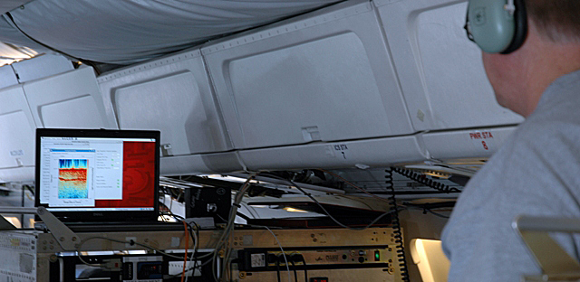
Photo Credit: Jill Hummels/University of Kansas |
University of Kansas scientist Chris Allen at the controls of the MCoRDS radar as the NASA DC-8 flies over Antarctica. The radar measures ice thickness as well as the varied terrain below.
|
Ice Bridge instruments
Airborne campaign boasts high-tech lasers, radars for ice survey
Posted October 23, 2009
The Airborne Topographic Mapper (ATM)
The Airborne Topographic Mapper (ATM)  , developed at NASA Wallops Flight Facility in Wallops Island, Va., is an airborne laser that pulses laser light in circular scans on the ground. The pulses reflect back to the aircraft and are converted into elevation maps of the ice surface. By flying ATM over the same swath of ground covered by ICESat, researchers can compare the two data sets and calibrate them so that aircraft can continue the record keeping after the satellite data ends.
The primary instrument on these flights, ATM was flown from Punta Arenas over the Antarctic in 2002, 2004 and 2008 aboard a Chilean Navy P3 aircraft.
Multichannel Coherent Radar Depth Sounder (MCoRDS)
University of Kansas  scientists will fly MCoRDS, a radar used to measure ice sheet thickness. It can also map the varied terrain below the ice, which is important for computer modeling of the future behavior of the ice.
Snow Radar
University of Kansas scientists will fly a snow radar, which measures the thickness of snow on top of sea ice and glaciers, allowing researchers to differentiate between snow and ice and make more accurate thickness measurements.
Ku-Band Radar Altimeter
University of Kansas’ third instrument, the Ku-Band Radar Altimeter, penetrates through snow to measure the surface elevation of sea ice and ice sheets. It can also measure sea surface elevation.
Gravimeter
The gravimeter, managed by Columbia University , will measure the shape of seawater-filled cavities at the edge of some major fast-moving major glaciers.
Laser Vegetation Imaging Sensor
Scientists at Goddard developed the Laser Vegetation Imaging Sensor , which can map large areas of sea ice and glacier zones from a high altitude.
NASA DC-8 Airborne Laboratory
NASA’s DC-8 jetliner is a modified jetliner that supports instruments used to collect data for field research. It is so large that it can’t be flown out of Antarctic runways. A particularly challenging feature of the flights for this campaign is that they will be very long, about 11 hours each — four hours each way over the Southern Ocean and about three hours over Antarctica.
Return to main story: NASA Ice Bridge

;)
