Penguins From SPAAAAAACCCEHow Scientists Count Emperor Penguins From Orbit…and Why They Want ToPosted February 5, 2019
Scientists want to know how many emperor penguins there are in the world, and they’re using Earth-observing satellites to count them. 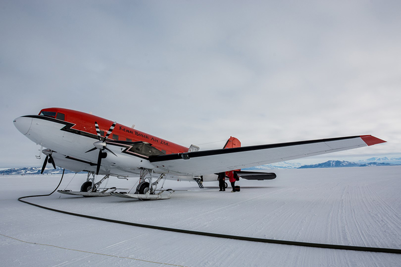
Photo Credit: Mike Lucibella
LaRue and her team prepare to board a Basler to fly by five emperor penguin colonies along the coast of the Ross Sea.
"Our idea is to come up with a population estimate for emperor penguins around the continent over the course of 10 years," said Michelle LaRue, an ecologist at the University of Minnesota and principal investigator on the project. "And in addition…looking at habitat suitability and some of the environmental factors that may be causing their population fluctuations." With this decade of data, the team wants to then be able to compare populations from the different colonies with other environmental factors nearby. Because they nest on sea ice, ice which grows and retreats on annual basis, Emperor penguins are thought to be particularly at risk to changes in climate. "We have the ability to test all kinds of environmental variables and see what's going on and see how the population dynamics change from year to year and see if there's a signal there that might indicate why certain populations are going up and down," LaRue said. In October and November, a team of researchers flew near six different penguin colonies to verify what those passing satellites have been telling them about how many birds roost in the colonies. With the data taken from these flights to validate their satellite counts, the researchers hope to put together the most accurate global census of emperor penguins ever. Their research is supported by the National Science Foundation, which manages the U.S. Antarctic Program. 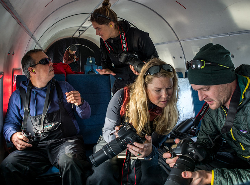
Photo Credit: Mike Lucibella
(Left to right) Leo Salas, Sara Labrousse, Michelle LaRue and David Iles prepare their cameras as they near an emperor penguin colony.
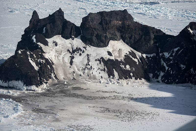
Counting Penguins in the Space AgeNumerous polar-orbiting satellites pass over Antarctica every day, photographing the landscape below. These images have been invaluable to researchers making detailed maps of the continent and tracking flowing ice, but they have also been used to locate emperor penguin colonies around the coast of Antarctica. Emperors breed on the sea ice, also known as fast ice, and spend most of their time huddled together on top of it. The best way to pick out an emperor penguin colony is to look for their droppings. "They leave a brown guano stain on the fast ice and that's how we know that's what we're looking at," LaRue said. "There tends to be a really small brown stain, and sometimes it's relatively large, and you can kind of pick it out, and that's how you can tell there’s an emperor penguin colony there. Their guano stain means they're present." Finding the colonies using satellite images is relatively easy, but the images can also be used to count how many birds are at each one. Some of the highest quality, commercially available satellite images have resolutions of roughly one square foot, which is just sharp enough to see individual birds from space. LaRue and her team have been developing an algorithm that can look at a satellite photo of a penguin colony and count all of the penguins in it. "The way we do that is a process called supervised classification, where we effectively train the computer to tell the difference between pixels of penguins and other items that might be on the landscape," LaRue said. "Then it tells us how many pixels of penguins there are which is great but then we need to be able to turn the number of pixels into an actual number of penguins." It's potentially a handy tool, but the researchers need to know exactly how accurate it is. 
Photo Credit: Mike Lucibella
Sara Labrousse gets into position to photograph a penguin colony.
Penguin FlybysLaRue and her team traveled to Antarctica to "ground truth" some of the counts in hopes of developing more accurate penguin counting algorithms. "'Ground truthing,' I guess, is a bit of a misnomer, we're actually flying aerial surveys," LaRue said. She and her team overflew six penguin colonies along the Ross Sea, taking detailed photos of the areas and hand counting the number of birds at each. Because these images are more detailed than the satellite images, these hand counts are more accurate. By comparing counts taken from satellite data with these flyby counts, the team can get a better idea of how many penguins live at a colony and how well they're able to count them with the satellite images. "So, what we have to do for field work is figure out how many penguins there are at multiple colonies… so that when we estimate that from the high resolution [satellite] imagery we can come up with a model that is applicable to all colonies around the continent," LaRue said. Altogether, there are about 54 known emperor penguin colonies throughout Antarctica. Seven of them, including some of the largest, are along the coast of the Ross Sea, relatively close to NSF's McMurdo Station. 
Photo Credit: Mike Lucibella
Michelle LaRue (left) looks ahead as Sara Labrousse and David Iles photograph a passing penguin colony.
The team flew in a converted DC-3 airplane, known as a Basler, past five of these coastal colonies, taking high-resolution photographs. In addition, they flew five flights in a helicopter by the colony at Cape Crozier on Ross Island. As they passed by, the team snapped photos using digital cameras equipped with powerful zoom lenses. "You basically zoom in at the maximum… and you shoot the colony going from the bottom to the top while the plane or the helicopter is flying. So, trying to get all the penguins, not missing any corner," said Sara Labrousse, a postdoctoral student at Woods Hole Oceanographic Institution. The size of these penguin colonies changes throughout the year. The birds leave the colony to hunt for food at various times so the apparent size of the colony would appear to change depending on when an image was taken. "What we want to know is how much does that fluctuate from one week to next week," LaRue said. "We want to have a margin of error to understand and so that's why we're going there so many times, to figure out what that margin of error might be." The team flew by the colony at Cape Crozier several times over the course of their field season, gauging how much over the course of a month the colony size changed. They timed each flight to correspond with a satellite pass to compare the counts from each set of images. On the Basler, the team wanted to get a broader look at multiple locations. They passed by colonies at Beaufort Island, Franklin Island, Cape Washington, Cape Roget and Coulman Island, one of the world's largest colonies with an estimated 20,000 birds, one of the largest colonies in the world. 
Photo Credit: Mike Lucibella
Michelle LaRue (foreground) and Sara Labrousse zoom in on a cluster of emperor penguins on the ice below.
"We will have aerial counts that are highly precise for a small number of colonies," said David Iles, also a postdoctoral student at Woods Hole. "Then we'll have satellite counts at the same time of year for every colony on the planet." Checking an AlgorithmAfter returning with hundreds of close-up photos of the colonies, the team stitched them all together to make giant detailed photo mosaics of each colony. Then they set about counting, by hand, the thousands of birds in each colony. It took as long as 16 hours to hand count all of the birds in some of the largest colonies. It's tedious work, but it gives the most accurate total that can be compared to their algorithm that counts birds in satellite images. "For that small subset where we have aerial counts and satellite counts, we build a statistical model that basically takes the satellite count and predicts how many actual birds would be there on the ground," Iles said. "Then we just basically use that model to project to the sites where we only have satellite counts." 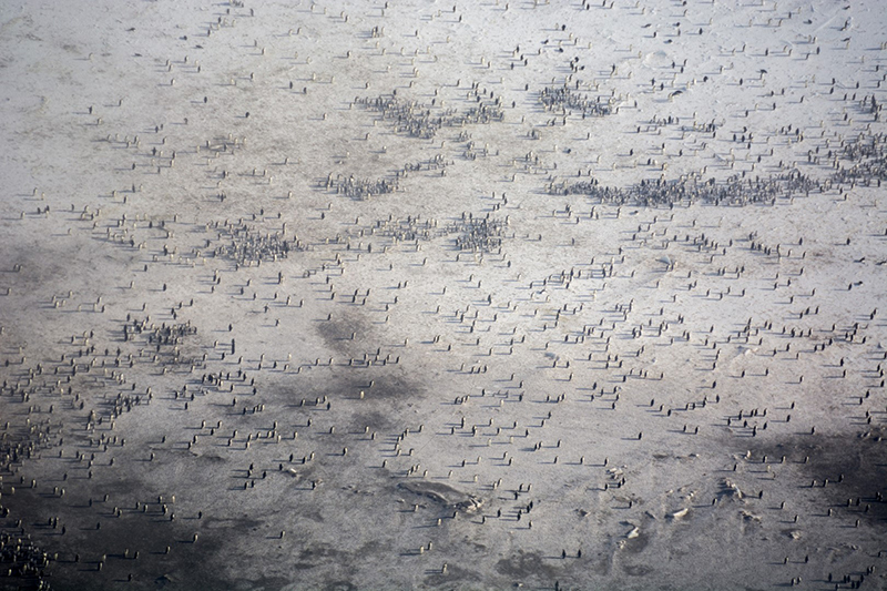
Photo Credit: Mike Lucibella
The team will stitch together hundreds of zoomed in photos like this to create detailed images of each of the colonies and meticulously count every penguin in them to get an accurate count and compare that to satellite counts.
A Decade of DataCreating a program that automatically counts penguins would unlock vast amounts of data for ecologists. Satellites with high enough resolution to image individual birds have been taking photos of Antarctica's coastline for a decade, but there are just too many birds to reasonably count by hand. "This is going to be one of the coolest time-series ever because for every colony on the planet, there's ten years in a row of how many birds are there," Iles said. "You can look at each individual colony and look at its sea ice conditions and its position and how many birds are there and you can start to look at the kinds of factors that seem to be driving these population swings, proximity between colonies all that sort of stuff." Being able to track the ebb and flow every colony for ten years would give them unprecedented insight into their population patterns around the continent. "As the air temperatures and sea surface temperatures may warm in the future, how would their habitat be affected and how will their populations be affected by that?" LaRue said. "There have been some modelling studies that look into that, but this will be the first time ever that we'll be able to actually look and say 'Ok, over the course of 10 years here’s actually how many birds were here from year to year.' We'll have an empirical way to test some of those questions." With this decade of data, the team wants to then be able to compare populations from the different colonies with other environmental factors nearby. Because they nest on the sea ice, emperor penguins are thought to be particularly at risk to changes in climate. 
Photo Credit: Mike Lucibella
LaRue (front seat) and Labrousse also used a helicopter to fly by an emperor penguin colony multiple times at Cape Crozier to see how the apparent size of the colony changes over the course of the season.
"We have the ability to test all kinds of environmental variables and see what's going on and see how the population dynamics change from year to year and see if there's a signal there that might indicate why certain populations are going up and down," LaRue said. Sea ice always changes somewhat from year to year, but if local conditions change significantly for a long stretch of time, it could dramatically affect the health of the penguin population; "it will affect differently the populations depending on the region," Labrousse said. They plan on looking at how populations respond to changes in sea-ice extent, as well as for other factors that might affect the animals. "The fast ice extent is really important because it's the distance where they have to travel to get to open water to get food," Labrousse said. Right now, the team is still developing their penguin counting algorithm and sifting through the data they collected this season. NSF-funded research in this story: Michelle LaRue, University of Minnesota, Award No. 1744989. |

For USAP Participants |
For The Public |
For Researchers and EducatorsContact UsNational Science FoundationOffice of Polar Programs Geosciences Directorate 2415 Eisenhower Avenue, Suite W7100 Alexandria, VA 22314 Sign up for the NSF Office of Polar Programs newsletter and events. Feedback Form |