|
Increasing coverageAntarctic sea ice reaches record extent in 2013 as part of decadal growth trendPosted October 25, 2013
Antarctic sea ice extent reached a new record high maximum extent last month, according to the National Snow and Ice Data Center (NSIDC) Sea ice is formed from frozen seawater in polar regions. Most sea ice occurs as pack ice, which drifts across the ocean surface. In contrast to a sharp downward trend in September Arctic sea ice, Antarctic September sea ice has been increasing at 1.1 percent per decade relative to the 1981 to 2010 average. Scientists attribute the increase in Antarctic sea ice extent largely to stronger circumpolar winds, which blow the sea ice outward, increasing its extent, according to an NSIDC press release On Sept. 22, sea ice surrounding the southernmost continent grew to 19.47 million square kilometers, about 3.6 percent higher than the 1981 to 2010 average Antarctic maximum, based on the satellite record. That represents an ice edge that is 35 kilometers farther north on average. The September 2013 monthly average was also a record high, at 19.77 million square kilometers, slightly higher than the previous record in 2012, according to NSIDC, which is partly funded by the National Science Foundation 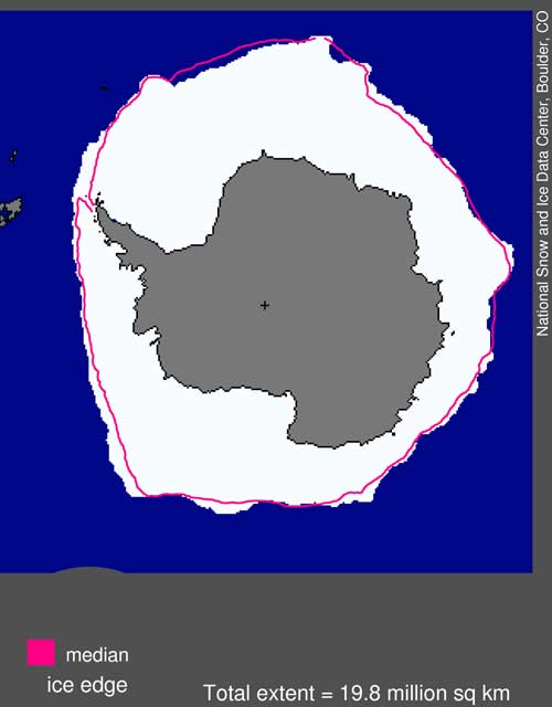
Photo Credit: NSIDC
Antarctic sea ice extent for September 2013 was 19.77 million square kilometers. The magenta line shows the 1981 to 2010 median extent for that month. The black cross indicates the geographic South Pole.
However, there is considerable variation of sea icefrom place to place around the continent, according to a feature The reasons behind the increase in wind strength are less clear, though some researchers have suggested that ozone depletion may be the culprit. The destruction of ozone each year above the Antarctic has allowed the layer of atmosphere called the stratosphere to cool. Meanwhile, the troposphere, the layer of atmosphere closest to Earth, is warming. The temperature differential between the two layers may play a role in changes in atmospheric circulation. A paper The study suggests that stronger westerly winds swirling around the South Pole can explain 80 percent of the increase in Antarctic sea ice volume in the past three decades, a press release The polar vortex that spins around Antarctica is not just stronger than it was when satellite records began in the 1970s. It also has more convergence, meaning it shoves the sea ice together to cause ridging. Stronger winds also drive ice faster, which leads to still more deformation and ridging. This creates thicker, longer-lasting ice, while exposing surrounding water and thin ice to the blistering cold winds that cause more ice growth. In a computer simulation that includes detailed interactions between wind and sea, thick ice – more than two meters thick – increased by about 1 percent per year from 1979 to 2010, while the amount of thin ice stayed fairly constant. The end result is a thicker, slightly larger ice pack that lasts longer into the summer. “You’ve got more thick ice, more ridged ice, and at the same time you will get more ice extent because the ice just survives longer,” Zhang said in the UW press release. |

For USAP Participants |
For The Public |
For Researchers and EducatorsContact UsNational Science FoundationOffice of Polar Programs Geosciences Directorate 2415 Eisenhower Avenue, Suite W7100 Alexandria, VA 22314 Sign up for the NSF Office of Polar Programs newsletter and events. Feedback Form |

