|
Flight availabilityNASA IceBridge campaign to be based out of McMurdo Station for first timePosted November 15, 2013
A NASA NASA’s Operation IceBridge “We’re pretty excited to be going to McMurdo this season. It will be our first-ever IceBridge deployment to McMurdo,” said Christy Hansen, project manager for IceBridge, which is based at NASA Goddard Space Flight Center 
Photo Credit: Jim Yungel/NASA
The IceBridge P-3B takes off from NASA's Wallops Flight Facility for the five-day trip to McMurdo Station.
IceBridge is touted as the biggest airborne survey of Earth’s polar ice ever flown. The project is intended to bridge the gap between NASA’s Ice, Cloud and Land Elevation Satellite (ICESat) Each year IceBridge scientists and engineers fly missions across Greenland and Antarctica during their respective summer seasons. Until this year, IceBridge had been based at Punta Arenas, Chile, which gave the team access to West Antarctica and the Antarctic Peninsula. However, nearly half the flight time was spent crossing from South America to Antarctica. “We’re going to collect more science hours of data per flight time,” Hansen said of the switch to McMurdo, which is located on Ross Island and connected to the rest of the continent by the Texas-sized Ross Ice Shelf. “We can start collecting science data as soon as we take off.” The planes used by IceBridge – modified DC-8 and P-3B “The data we collect [are] important for climate scientists to understand how ice sheets change over time, what is driving this change,” explained Michael Studinger One of the key IceBridge instruments 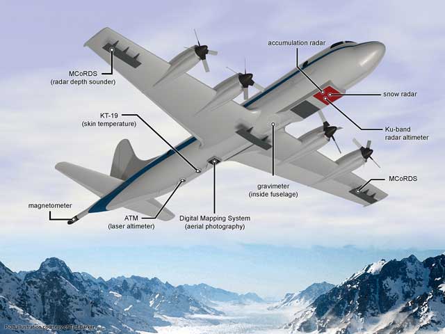
Graphic Credit: Tim Barker
Graphic of P-3B with location for science instrument sensors indicated.
“If the thickness of ice changes, it will end up as water in the ocean, which will raise sea level,” Studinger noted. “What happens in Antarctica really matters along the coasts worldwide.” More than 40 percent of the world population lives within 150 kilometers of the coast, according to the United Nations Atlas of the Oceans In addition to the primary laser altimeter, the IceBridge airborne laboratories are also outfitted with various radars Each radar instrument uses a different frequency band, which gives them the ability to examine the entire ice column, ranging from the surface, through accumulated snow and all the way down to the bedrock below, according to the NASA IceBridge website. It took more than a year of planning to bring IceBridge to McMurdo Station, according to Chad Naughton, a project manager for the USAP. “IceBridge is a complicated project with a lot of resource [needs],” Naughton said, adding that NASA’s preparedness and previous polar experience made planning the mission much easier than it might have been. 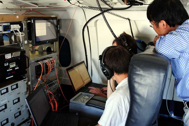
Photo Credit: Emily Schaller, NSERC/Antarctic Photo Library
Scientists test instruments aboard NASA's DC-8 during a previous IceBridge campaign over Antarctica.
“NASA was very organized,” he said. The 16-day U.S. government shutdown almost unraveled those plans. The NSF had been forced to begin drawing down its operations just as the main austral summer field season was scheduled to begin in early October. While funding was restored after the U.S. Congress ended its budget impasse, some research projects were deferred or reduced in scope due to the logistical hiatus during a critical part of the year. Operation IceBridge itself will only have six days of available flight days versus the original 24 that had been planned. That’s because the mission is starting nearly a month late, and the runway that will be used by NASA’s P-3B is located on sea ice. By late November, the sea ice will become too unstable to use. Air operations will switch to Pegasus Airfield Hansen said the IceBridge flight plan is very flexible, with numerous mission targets possible based on weather conditions. “We plan a lot more missions than we intend to fly,” she said. The NASA team hopes to return to McMurdo in the 2015-16 austral summer after a major refit of the P-3B next year that will ground the plane for the 2014-15 field season. Studinger said Operation IceBridge is scheduled to continue flying for at least one more year in both Greenland and Antarctica after ICESat2 launches in 2016. “We need to make sure the measurements we are doing are consistent with the measurements that are being done by ICESat2,” he said. “In order to do this, we need overlap between the two measurements.” That should ensure that ice sheet measurements critical to climate science continue without interruption through 2017. “The science community is very excited about our datasets,”Hansen said. |

For USAP Participants |
For The Public |
For Researchers and EducatorsContact UsNational Science FoundationOffice of Polar Programs Geosciences Directorate 2415 Eisenhower Avenue, Suite W7100 Alexandria, VA 22314 Sign up for the NSF Office of Polar Programs newsletter and events. Feedback Form |

