|
Off roadPGC provides stunning new imagery for Google Street ViewPosted January 3, 2014
Google Street View has gone off road – way off road. The Internet giant recently unveiled its latest batch of panoramic imagery for its Google Maps and Google Earth applications that include some remote and stunning areas of Antarctica. The imagery was captured with the help of the Polar Geospatial Center (PGC) “It’s very exciting because there’s so much more potential for it being useful to scientists,” said Cole Kelleher 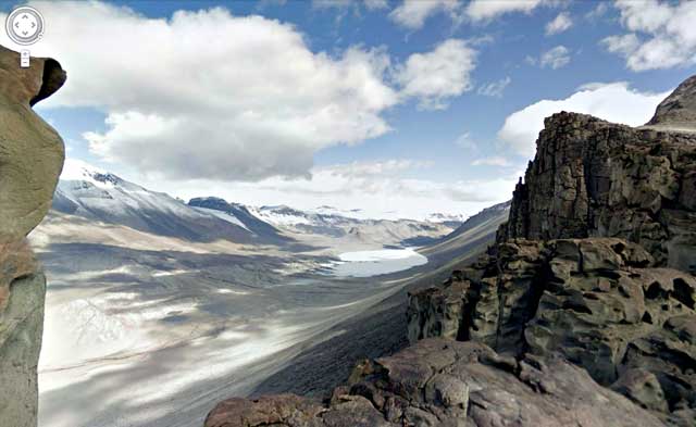
Photo Credit: Google Street View
Street View imagery of Bull Pass in the McMurdo Dry Valleys.
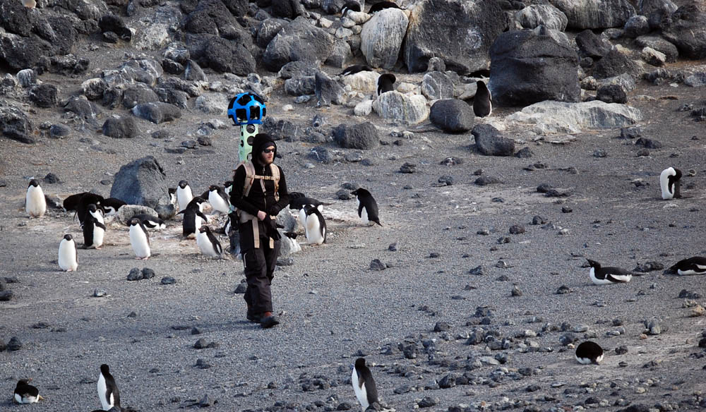
Kelleher was responsible for capturing much of the imagery using Google’s Trekker, a modified backpack that carries a 42-pound camera and battery. The Trekker is operated by a smart phone and consists of 15 lenses angled in a different direction so the images can be stitched together into 360-degree panoramic views. The mobile Trekker camera was introduced last year and first used in Arizona’s Grand Canyon. Photos are taken roughly every 2½ seconds while the walker is in motion. The basketball-sized ball that contains the camera sat about a foot above Kelleher’s head, making the device a bit awkward to carry at times. “It’s very top heavy. … That was probably the toughest part – taking care of it and trying not to damage it,” Kelleher said. “I told [Google] it would probably not come back in the condition it goes out in. You’re out in the middle of nowhere. It’s tough terrain. I only fell about three times.” Many of the Street View images released are from the McMurdo Dry Valleys 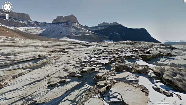
Photo Credit: Google Street View
A view of the Mars-like Arena Valley in the McMurdo Dry Valleys.
“I think it is important that people will be able to see areas such as the McMurdo Dry Valleys in Google Street View because many people imagine Antarctica as a flat white continent when in fact there are extremely diverse landscapes here with tremendous beauty and power,” Kelleher said. The imagery was shot during the course of field research by Kelleher and PGC geospatial analyst Spencer Niebuhr “We were already doing research in the area,” said Kelleher during an interview at McMurdo Station The informal partnership between PGC and Google took shape more than two years ago, facilitated by a former Google employee who worked a summer season at the South Pole Station Antarctica Street View links Last year, Google released the first batch of Antarctic Street View imagery that had been shot by PGC, as well as the New Zealand Antarctic Heritage Trust A different type of Google camera will be flown this year by a Basler aircraft by a team from the Center for Remote Sensing of Ice Sheets (CReSIS) The camera will be used to collect fine-resolution imagery of the ice surface along the plane’s flight path, as part of a pilot project, according to Carl Leuschen, CReSIS deputy director who oversees the development of the radar systems. “We’ll see how the data looks,” Leuschen said. Google Street View reportedly covers more than five million miles and includes about 40 countries – and one very cold continent. “I’m excited to see it now live and out there,” Kelleher said. NSF-funded research in this story: Paul Morin, University of Minnesota, Award No. 1043681 |

For USAP Participants |
For The Public |
For Researchers and EducatorsContact UsNational Science FoundationOffice of Polar Programs Geosciences Directorate 2415 Eisenhower Avenue, Suite W7100 Alexandria, VA 22314 Sign up for the NSF Office of Polar Programs newsletter and events. Feedback Form |