Pulse on PolynyasScientists to employ UAV to measure atmosphere over sea ice phenomenonPosted May 8, 2009
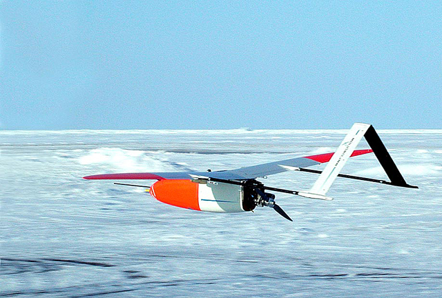
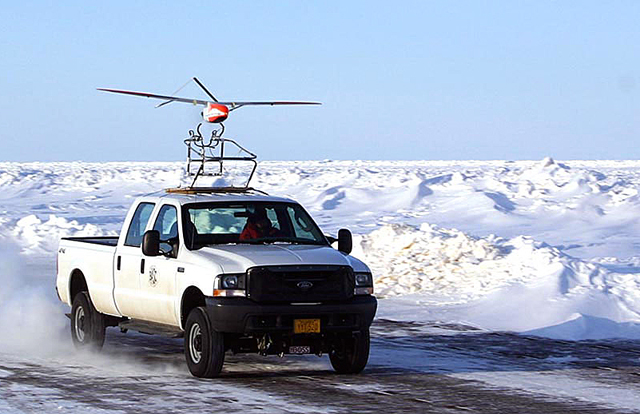
There are few places in Antarctica not covered by snow and ice. In the winter, even the surrounding ocean turns to ice — sea ice But there are some bare spots near the continental margins, isolated pools of seawater that often remain open thanks to strong winds that forcefully roll down the polar plateau with bone-rattling cold. Sea ice forms as the cold air meets the relatively warm ocean, but the wind continuously pushes the newly formed ice away from the continent. These polynyas “The atmosphere doesn’t really feel what the ocean is doing, and the ocean doesn’t feel the atmosphere” with sea ice present, explained Cassano, an assistant professor in the Department of Atmospheric and Oceanic Sciences “The net effect on the ocean is that it becomes colder and it becomes saltier as a result of this polynya being in place,” Cassano said. That cold, saltier water is denser than the surface water, so it sinks to the seafloor to form what scientists call Antarctic Bottom Water This global circulation system plays a major role in Earth’s climate. For example, the Gulf Steam, part of the thermohaline circulation, is responsible for maintaining Europe’s temperate climate as it charges toward the arctic despite the continent’s high latitude. Movie buffs might recall that in the sci-fi movie “Day After Tomorrow” it was the disruption of the thermohaline circulation that caused abrupt climate change and ushered in a new ice age. Surprisingly, the polynyas aren’t very big for the role they play in ocean circulation. The one in Terra Nova Bay “It’s not big at all in the global sense, but it has a global implication for what the ocean circulation is doing,” Cassano said. “That’s really the motivation here. We can look at a very small place, and it has a big, global consequence to it.” At least that’s what researchers believe. Much of what they know about the exchange of heat, the amount of cooling and the generation of salt water in an Antarctic polynya is a bit of conjecture. “We’ve never made measurements over the polynya in the winter,” Cassano said. “It’s all been theoretical and inferred through models, and we don’t know if we’re really right or not.” It’s all about timing and logistics. Most scientists funded by the National Science Foundation So the best time to arrive is in late August, a period in the parlance of the USAP known as Winfly, for winter fly-in. That’s when several flights land at McMurdo Station This year’s Winfly is a little different, with a large science component, including Cassano’s project, which involves using unmanned aerial vehicles (UAVs) to measure the atmosphere above the polynya in Terra Nova Bay, located near an Italian research station of the same name. “We’re really trying to get the first numbers to put on this [polynya], to say, ‘This is what’s actually happening,’ and ‘Yes it matches what we thought theoretically and what we’ve modeled on the computer,’” Cassano said. “This is why we’re not doing this during an easier time of year.” Flying high The UAV is an Aerosonde “We’re using their technology to make measurements in an equally harsh environment in the Antarctic, a place we wouldn’t be able to fly otherwise,” Cassano said. “It’s been used in [the arctic] before, but the Aerosonde has never been used in Antarctica before.” “No doubt the greatest challenge will be the weather,” said Nick Logan, a project manager for Aerosonde in Australia, via e-mail. “I anticipate many days where the weather is either too cold — minus 30 degrees C is about our limit — or too windy. The max speed for the aircraft is around 50 knots, and the max wind speed for take off is 25 knots head on and 8 knots across the runway.” Still, Cassano expects the UAV to make a little Antarctic history. While the British Antarctic Survey The team will actually bring four planes to the Ice, and operate out of Pegasus White Ice Runway “The pilot has continuous two-way communications with the aircraft,” he said. “He can command changes to airspeed, altitude, waypoints and can control payloads.” In addition to flying instruments that record standard meteorological data like wind speed and temperature, the planes carry instruments such as an infrared thermometer to measure the surface temperature of the water or the sea ice, and a camera to image the surface of the polynya. “On some missions, we’ll carry a laser altimeter to measure the UAV’s height above the surface very accurately,” Cassano said. “This will allow us to fly at lower altitudes than we could otherwise. “The low altitude flights are important because at low altitudes we’ll be able to use the measured temperature, humidity, and wind to estimate the turbulent heat fluxes from the polynya — how much heat and moisture are being transferred to the atmosphere from the ocean.” The planes, with a wingspan of about three meters, will also carry “mini-dropsondes,” a device identical to balloon-borne radiosondes, which measure various atmospheric conditions and transmit the information to a receiver on the aircraft. The dropsondes take vertical profiles of temperature, pressure, humidity and wind as they fall through atmosphere. Meanwhile, in collaboration with the Italians and scientists at Columbia University’s Lamont-Doherty Earth Observatory “We’ll use this data in conjunction with our UAV atmospheric measurements to look at the effect that the atmosphere is having on the ocean state,” Cassano said.
NSF-funded research in this story: John Cassano and James Maslanik, University of Colorado at Boulder, Award No. 0739464 |


For USAP Participants |
For The Public |
For Researchers and EducatorsContact UsNational Science FoundationOffice of Polar Programs Geosciences Directorate 2415 Eisenhower Avenue, Suite W7100 Alexandria, VA 22314 Sign up for the NSF Office of Polar Programs newsletter and events. Feedback Form |


