|
Page 2/2 - Posted October 14, 2011
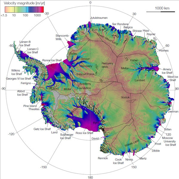
Scientists take to the field, skies to learn more about West AntarcticaAnother major NSF-funded project tackling ice sheet dynamics is WISSARD Members of the WISSARD team presented some of the findings from recent fieldwork to map one of the key sites in their investigation, subglacial Lake Whillans, with radars and seismic imaging. In coming years, researchers will use a hotwater drill to access the lake and other parts of the subglacial waterworks, sending robots and instruments into the ice-covered environment to learn more about its mysteries and the role it plays in ice sheet dynamics. Few among the group would dispute that future research in West Antarctica and elsewhere will increasingly rely on remote sensing — instruments aboard satellites or aircraft that can provide various details about the ice regarding its thickness, layers and even motion. Bernd Scheuchl Using satellite data from the Japanese, Canadian and Europeans, the NASA-funded, color-coded map shows where ice drains from the interior to the exterior of the continent. The colors represent the speed of the ice, making the animated map that Scheuchl presented look like thick-trunked trees (where the glaciers flow to the sea or terminate at ice shelves), with bristling branches (where small rivers of ice begin to stream from the interior). 
Graphic Credit: NASA/JPL-Caltech/UCI
First complete map of the speed and direction of ice flow in Antarctica, derived from radar interferometric data.
Recent air campaigns above Antarctica are also changing the way scientists see the continent. A project called ICECAP For three field seasons, the research team flew an upgraded World War II-era DC-3 aircraft with a suite of geophysical instruments to study the ice and underlying rock below Antarctica’s larger ice sheet. The findings from the project, partly funded by NSF, should provide important insight into the history of ice in Antarctica, as well as improve computer models of how the ice sheet might behave in the future as the climate changes. [See previous article: Capped off.] “We are moving into a different world,” noted Duncan Young ICECAP will continue mapping East Antarctica’s ice for another two field seasons, as part of the NASA initiative called Operation IceBridge The 2011 Antarctic IceBridge campaign will feature the return of NASA’s DC-8 “The areas where we go and collect data are pretty much defined by where changes are happening, where we see changes happening in satellite missions,” said Michael Studinger That seems to be the mantra the workshop scientists have adopted — go where the changes are happening. The question of how Antarctica will respond in a changing world will take them to crevassed ice shelves and ice-choked seas. It will require innovative technologies aboard aircraft or robots sent to explore subglacial seas. “The question is larger than any one investigator,” Bindschadler said.Back 1 2 |


For USAP Participants |
For The Public |
For Researchers and EducatorsContact UsNational Science FoundationOffice of Polar Programs Geosciences Directorate 2415 Eisenhower Avenue, Suite W7100 Alexandria, VA 22314 Sign up for the NSF Office of Polar Programs newsletter and events. Feedback Form |


