Seeking shelterSearch for Amundsen's tent at South Pole continues a century laterPosted Dec. 15, 2011
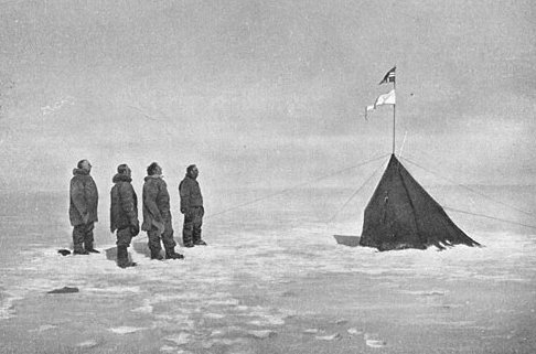
One of the iconic images that has survived from the Heroic Age of Antarctic Exploration shows Norwegian Roald Amundsen and three members of his party gazing upon a small tent pitched on the polar plateau near where they had calculated the geographic South Pole to be located. The picture is both solemn and sublime, as if the four men were looking upon a holy monument. In a sense, it was — a modest canvas shrine to polar exploration. They had become the first people to reach the South Pole on Dec. 14, 1911. Exactly 100 years later, Amundsen’s feat was commemorated by his countrymen, who held a ceremony at the Amundsen-Scott South Pole Station The only thing missing? Amundsen’s humble tent, dubbed Polheim, which means “house of the pole” in Norwegian. But Bill Spindler thinks he knows where Polheim is hiding. “One thing that many Polies have done since, well, 1957, is try to locate Amundsen’s tent, either on paper or in person,” says Spindler, who has worked on and off with the U.S. Antarctic Program (USAP) In a sense, Polheim was the first “station” at the South Pole, a small tent that had only been taken on the trip in case the Norwegians had to separate. It had been sewn of thin, windproof material by sail maker Martin Rønne during the journey south in the expedition’s ship, the Fram. An extended pole over the tent served as a flagpole for the Norwegian flag and a pennant on which FRAM was painted. Guy ropes held the tent in place on all sides. Inside Polheim, Amundsen had placed a small bag containing a letter to King Haakon of Norway about the grand accomplishment of his team, along with a note to his British rival, Capt. Robert Falcon Scott, who arrived about a month later. A photo of Scott’s party with Polheim contrasts sharply with the Norwegian photograph, the Brits obviously disheartened about the second-place finish. The Norwegians also left behind some extra equipment, including a sextant with glass horizon, three reindeer-skin foot bags, some footwear and gloves. A plaque with the names of the five men was also fastened to the tent pole. A keen student of Antarctic history, Spindler has conducted exhaustive research about the current location of Polheim, which had disappeared below the ice by the time the first Americans arrived in 1956 to build a research station. The story begins with Amundsen’s own book, The South Pole, published shortly after his successful return. 
Photo Credit: Christine Schultz/Antarctic Photo Library
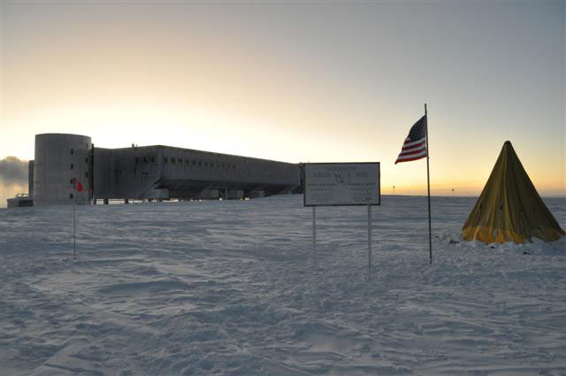
The modern-day South Pole, with a Scott tent next to the geograph.
In the book’s appendix is a short analysis of the party’s survey data by Norwegian Anton Alexander, a “mathematical master” who had calculated the astronomical observations of other expeditions of the era, including Amundsen’s successful navigation of the Northwest Passage. Alexander had been enlisted to verify that Amundsen had indeed located the South Pole. Unlike today, where GPS satellites enable millimeter-level accuracy of geographic points of interest, the explorers in the early 20th century had to rely on cruder measurements. Both Amundsen and Scott identified the pole by making astronomical observations of the sun using an instrument called a sextant. In a paper first published in 1996 by Gordon Shupe and Larry Hothem, with the U.S. Geological Survey (USGS) “When at the geographic location for the South Pole, the sun is above the horizon six months of the year. Through a 24-hour period, the sun moves parallel to the horizon a complete rotation around the geographic pole. It gradually rises to its highest angle above the horizon on Dec. 21. “Observations to measure the angle of the top edge of the sun above the horizon were made with a sextant or similar instrument. When the angle or altitude above the horizon is equal, the observer is standing at the geographic location for the South Pole. The accuracy for this method is estimated to be about 300 meters (about 1000 feet).”1 2 Next |


