|
Science - Earth Most Recent
Quick Find
More ResultsMay
02
2022
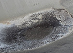
Wintertime flow of Blood Falls caught on camera for the first timeResearchers have caught a wintertime release of brine from Blood Falls on camera for the first time, but the exact cause of the curious phenomenon remains a mystery. Mar
21
2022
Antarctic fossils shed new light on the lives of ancient amphibiansFossils of extinct amphibians found in Antarctica are helping paleontologists reconstruct how these ancient creatures once roamed the planet and understand how life evolved in the wake of Earth's largest mass extinction. Oct
07
2021
Antarctic ice shivers from distant earthquakesAntarctica is the most remote continent on Earth, but new research shows it is still connected to what happens in the rest of the world. A new study finds large earthquakes can cause ice on the slopes of Antarctica's Mt. Erebus to quiver and vibrate, even when the quake happens thousands of miles away. Jul
26
2021
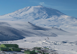
Tapping Erebus's PowerThe heat given off by Antarctica's Mount Erebus could help power instruments monitoring the volcano, giving scientists a way to study Erebus's lava lake during the long polar night for the first time. Researchers have found a way to harness the heat from the magma underneath Erebus and turn it into electricity that can power scientific instruments. May
26
2020
Pumping IronCold, hard iron is on the move. Particles of the ferrous metal are trickling into Antarctica's oceans, and marine algae are gobbling it up. Jul
08
2019
Listening to Rock MusicRocks are cracking up all over Antarctica's McMurdo Dry Valleys. Though it may take hundreds of thousands, or even millions of years, the slow but inevitable processes of weathering eventually reduce all rocks into sand or even clay. Jun
17
2019
Digging For FishiesThe mountains of Antarctica may seem an unlikely place to find fish, but they were exactly what a team of paleontologists working along the edge of the Polar Plateau last winter were looking for. In a region now defined by dry rocky terrain poking up through vast sheets of thick ice, the five-member team spent much of December and January scouring the exposed landscape for the remains of ancient fish. Apr
22
2019
The Dry Valleys' Briny DeepHunting for groundwater has come a long way from divining rods in the days of yore. This past austral summer, scientists in Antarctica used a sophisticated and highly sensitive instrument to look for water in one of the continent's driest regions. Oct
17
2018
Researchers Release the Highest Resolution Antarctic Map Ever ProducedResearchers at the National Science Foundation (NSF)-funded Polar Geospatial Center in September released the biggest and most detailed map of Antarctica ever produced. Jun
13
2018
A Chemical Detective Story: Why is Don Juan Pond So Salty?During winter, nearly everything in Antarctica freezes solid. Except Don Juan Pond. Though only about twice the area of an Olympic-sized swimming pool, and barely a foot deep, Don Juan Pond is famous for being the saltiest body of water on the entire planet. It is saltier even than the Dead Sea. May
03
2018
Paleo Gondwanaland Was Full Of LystrosaursAn expedition studying the aftermath of one of Earth's greatest global extinctions collected hundreds of prehistoric animal fossils from the mountains of Antarctica this past season. Ten researchers spent nearly six weeks camped in the Transantarctic Mountains, collecting fossils that formed following the great extinction at the end of the Permian era. Jun
30
2017
The Prehistoric Forests of the Frozen ContinentPaleontologists uncovered the fossil remnants of the oldest forest yet discovered in Antarctica. At about 270 million years old, the fossils come from an extinct species of tree known as Glossopteris. The fossils promise to offer paleontologists insights into the prehistoric climate and ecology of Antarctica, and the dramatic ecological changes that were about to sweep across the continent. May
17
2017
Tag! You're it!A number of Adelie penguins around the Ross Sea are sporting sophisticated new leg bands this year. Ornithologist David Ainley and his team attached new electronic tags to about 150 penguins to record where each penguin goes and how deeply it dives under water. The tagging project ties in with a broader effort that he's been spearheading for 20 years, monitoring Adelie penguin populations and demographics around Ross Island.
|
||||||||||||||||||||||||||||||

For USAP Participants |
For The Public |
For Researchers and EducatorsContact UsU.S. National Science FoundationOffice of Polar Programs Geosciences Directorate 2415 Eisenhower Avenue, Suite W7100 Alexandria, VA 22314 Sign up for the NSF Office of Polar Programs newsletter and events. Feedback Form |