|
Last threadWilkins Ice Shelf further disintegrates, ice bridge ready to collapsePosted July 11, 2008
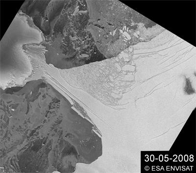
The Wilkins Ice Shelf is experiencing further disintegration that is threatening the collapse of the ice bridge connecting the shelf to Charcot Island. Since the connection to the island helps to stabilize the ice shelf, it is likely the break-up of the bridge will put the remainder of the ice shelf at risk, according to a press release from the European Space Agency. Matthias Braun from the Center for Remote Sensing of Land Surfaces This break-up is puzzling to scientists because it has occurred in the Southern Hemisphere winter, and it is dissimilar to two events earlier this year at Wilkins that were comparable to the break-up of the Larsen-A and -B ice shelves. “The scale of rifting in the newly removed areas seems larger, and the pieces are moving out as large bergs and not toppled, finely divided ice mélange,” said Ted Scambos from the Boulder, Colo.-based National Snow and Ice Data Center “The persistently low sea ice cover in the area and data from some interesting sources, electronic seal hats [caps worn by seals that provide temperature, depth and position data] seems to suggest that warm water beneath the halocline [a strong salinity gradient] may be reaching the underside of the Wilkins Ice Shelf and thinning it rapidly — and perhaps reaching the surface, or at least mixing with surface waters,” he added David Vaughan of the British Antarctic Survey “Current events are showing that we were being too conservative when we made the prediction in the early 1990s that Wilkins Ice Shelf would be lost within thirty years — the truth is it is going more quickly than we guessed.” The Wilkins Ice Shelf, a broad plate of floating ice south of South America on the Antarctic Peninsula that is connected to Charcot and Latady Islands, had been stable for most of the last century before it began retreating in the 1990s. By studying satellite images since the 1990s, Braun and his colleague Angelika Humbert from the Institute of Geophysics, Münster University, have found the Wilkins Ice Shelf has break-up events with losses of large areas rather than ordinary, continuous calving. For instance, in February 2008, an area of about 400 square kilometers broke off from the Wilkins Ice Shelf, narrowing the ice bridge that connects it to Charcot and Latady Islands down to a 6-kilometer strip. (See related story: Breaking up.) In late May, it experienced further break-up, with an area of about 160 square kilometers breaking off, reducing the ice bridge to just 2.7 kilometers. (See related story: Winter no relief.) |

For USAP Participants |
For The Public |
For Researchers and EducatorsContact UsU.S. National Science FoundationOffice of Polar Programs Geosciences Directorate 2415 Eisenhower Avenue, Suite W7100 Alexandria, VA 22314 Sign up for the NSF Office of Polar Programs newsletter and events. Feedback Form |