Page 2/2 - Posted January 16, 2009
IPY collaborationThe U.S. National Science Foundation (NSF) The Australians are offering the use of their coastal research base, Casey Station Related Story
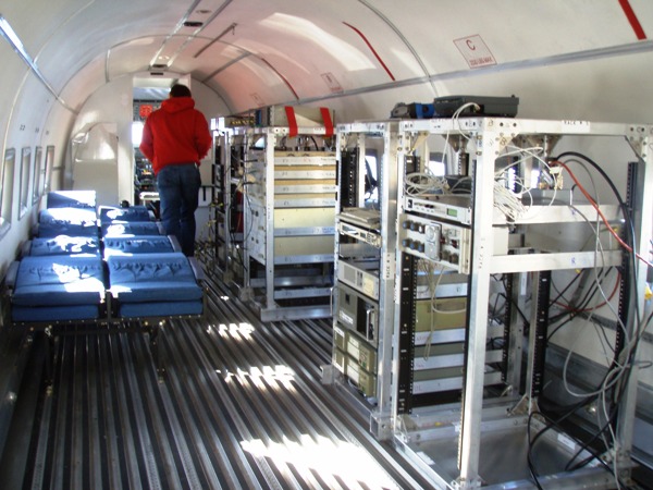
“This is a real IPY project, where everybody is chipping a lot in,” he noted. ICECAP will use the U.S. Antarctic Program’s McMurdo Station Added Wright, “I think the important thing is that the level of funding necessary, and the need to use the Antarctic bases [and] logistics of more than one country in order to access the regions of interest, means that projects of this scale can only be attempted as collaborations between nations.” A flying laboratoryThe ICECAP team will fly eight-hour missions out of Casey Station every good-weather day over a three-week period, according to Tas van Ommen The instruments aboard the plane include ice-penetrating radar to record echoes from the ice surface and base as well as from within the ice sheet, the University of Edinburgh’s Wright explained. Radar antennas installed beneath the wings of the aircraft transmit and receive the signals. “Data [are] recorded in flight, but require processing to make it useful,” he said. “We will also measure and record changes in the Earth’s gravity and magnetic fields, which, when combined with the radar measurements of ice thickness, can be used to determine information about the rock types and large-scale geology beneath the ice sheet.” The aircraft also sports a magnetometer within a tail-boom that sticks about 3 meters from the rear of the aircraft. “Accurate position information is important for this kind of survey, so GPS and aircraft altitude [and] orientation sensors are an important part of our equipment,” Wright said. Going way backThe survey will also help pinpoint the location where scientists might expect to find ice that is more than one million years old. The Australians are particularly interested in drilling an ice core that could provide a paleoclimate record that would complement data from marine sediment cores, according to van Ommen. Scientists can use ice cores to recreate past climate by analyzing the trapped gases and dust in the ice. The oldest ice core record, also from East Antarctica, stretches back about 800,000 years. The million-year mark is not just a psychological barrier to break, van Ommen explained. “We see in the marine sediment record that before about 1.3 million years … ice age cycles beat with a rhythm of around 41,000 years. For the last 800,000 years, though, ice ages have waxed and waned on a 100,000-year cycle.” Said Blankenship, “People really want to understand what throws the switch between 40,000 and 100,000 years. In other words, what does it take to change the climate like that, and it’s down there right around 1 million years.” Theories exist, van Ommen said, “and one general line of argument implicates a background change in overall planetary [carbon dioxide]. Understanding this has clear implications for predicting where we head in a high CO2 future, and in our general understanding of mechanisms.” NSF-funded research in this story: Don Blankenship (principal investigator), Ian Dalziel, Lawrence Lawver and Jack Holt, University of Texas at Austin, Award No. 0733025 |


For USAP Participants |
For The Public |
For Researchers and EducatorsContact UsU.S. National Science FoundationOffice of Polar Programs Geosciences Directorate 2415 Eisenhower Avenue, Suite W7100 Alexandria, VA 22314 Sign up for the NSF Office of Polar Programs newsletter and events. Feedback Form |


