Rising upStudy: More land above sea level captured more ice in Antarctica millions of years agoPosted September 11, 2009
Scientists Douglas Wilson and Bruce Luyendyk In a paper published in Geophysical Research Letters, a journal of the American Geophysical Union, the University of California Santa Barbara The idea not only inserts an intriguing chapter into the geologic evolution story of Antarctica but also provides new insight into how much ice the continent may have held as the so-called greenhouse world suddenly flipped — in geologic time — to an icehouse Earth about 34 million years ago. In about 100,000 years, Antarctica went from relatively ice-free to hosting the sort of huge continental ice sheets that exist today. However, until now, many scientists believed most of the ice accumulated on East Antarctica, which sits mostly above sea level even today. In contrast, modern West Antarctica is an archipelago, and the base of its marine-based ice sheet sits on bedrock that is below sea level in many places, which makes it more susceptible to climate change. Such topography 34 million years ago would have taken far longer for ice to build up into a heavyweight ice sheet in the west — about 20 million years more based on current models, according to the Wilson and Luyendyk. The problem is that the estimated sea level drop near the Eocene-Oligocene transition suggests more ice existed than what scientific models predict based on using the present topography for the early icehouse Earth. The mystery of the missing ice becomes less of a mystery with a larger landmass in West Antarctica, according to the UCSB scientists. “If you jack up that whole area by several hundred meters, you have a huge increase in land area where ice can accumulate,” Luyendyk explained. “A lot of the things discussed in the paper are not terribly surprising — and I think mildly controversial — but what I think we’ve done is just put it all together. Everything was higher in the past, and it’s subsided since then.” 
Photo Credit: UCSB
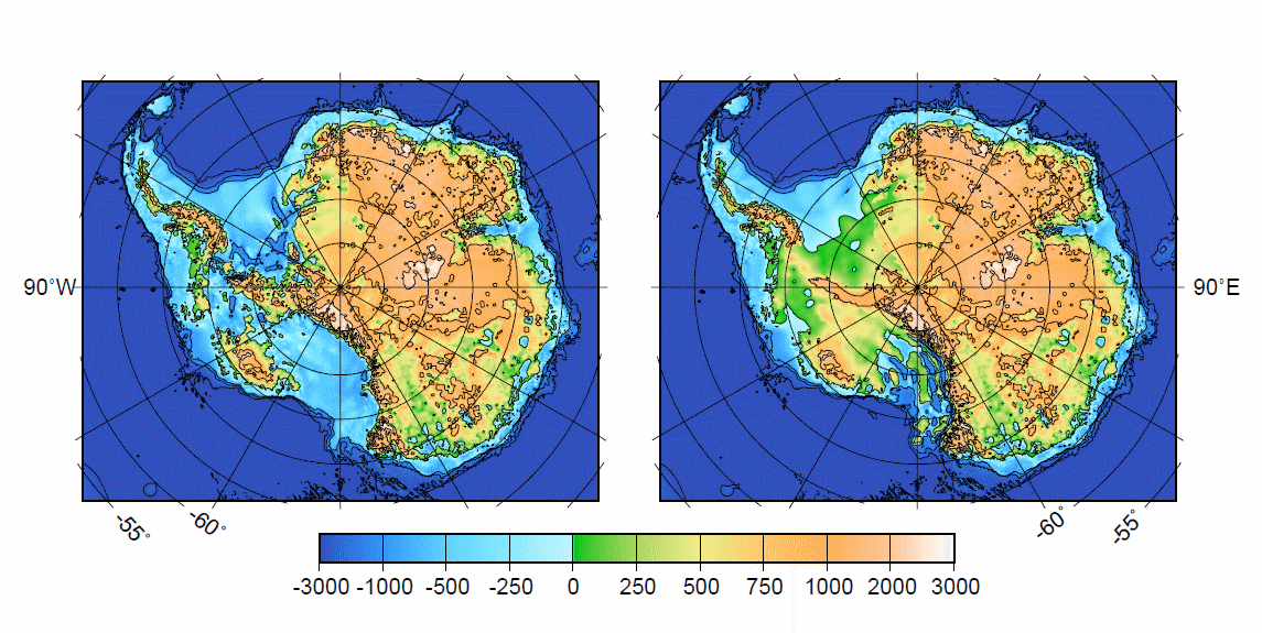
The static view of Antarctica, left, with only the ice sheet removed and the new reconstruction, right, with the additional landmass.
In other words, the land started to slide into the sea, like a hillside road that crumbles and falls off the slopeside. The reconstructed topography includes more land not only in the deep interior of West Antarctica but also where today the hundreds-of-meters-thick Ross Ice Shelf “The ice sitting there will move much more slowly,” Wilson said of the ancient landmass. “Not only will you have ice there, but that will cause ice on the rest of the continent to back up a little bit. Between the two effects, that creates potential for quite a bit more ice that can affect global sea level on the order of 10 to 20 meters.” Wilson said it appears the western subcontinent has been particularly active over the last 100 million years, undergoing a great amount of horizontal stretching — what geologists refer to as extension — that created large basins. Eventually, the extension ended, the crust cooled, and subsidence began, as the land began to shift down and submerge under water. “It’s a really big change based on a hundred million years of geology,” Wilson said. In addition to subsidence, large glaciers did their slow if efficient job of erosion, though Luyendyk said they need more data to constrain, or determine, how much land those rivers of ice grinded away. One key piece of evidence for the theory comes from a sediment core drilled into the seafloor in 1973. Deep Sea Drilling Project (DSDP) “What that sediment record tells us is that we had something that was above water, and some time after the continental glaciers started in Antarctica, it went from above sea level and it sank to being flooded by the ocean,” he said. “That’s an important check on what’s going up and what’s going down.” David Pollard “The main goals were to understand the timing and amplitude of this transition in the Antarctic ice sheet, and to establish the ranges of climate forcing for major growth and decay,” Pollard explained via e-mail. The key icehouse driver in their simulation, he said, was a decline in atmospheric carbon dioxide, the leading greenhouse gas of today. Some scientists also believe a major ocean current started around the same time — perhaps initiated by the opening of ocean gateways such as the ones between South America and Antarctica or Australia and Antarctica — helping to isolate the continent from warmer waters to the north. Pollard, who is collaborating with Wilson and Luyendyk, but was not an author in the AGU paper, said the idea of larger landmass in West Antarctica bolsters the E-O ice sheet model. “An outstanding mismatch in our E-O simulations was the total volume of Antarctic ice after the transition, with data suggesting a much greater volume than modeled,” he said. “The extra land surface above sea level in the new reconstruction supports greater area and volume of ice, and so helps to reduce this discrepancy. “The new topography is important not only for the initial growth at the Eocene-Oligocene boundary, but is the first step in incorporating evolving topography and its interactions with ice sheets over millions of years through the later Cenozoic,” he added. Wilson and Luyendyk said they’re interested in finding additional evidence like that from DSDP site 270 to fill in more details about the geologic evolution of West Antarctica. Antarctic sediment drilling programs like ANDRILL and SHALDRIL may offer an opportunity for additional data points — sites to confirm and refine their theory — if proposals receive funding in the future. “A study like this, which is going to have a major impact on the evolution of Antarctic ice sheets, just serves to remind us that there are lots of things to be found out,” Luyendyk. NSF funded research in this story: Bruce Luyendyk, University of California-Santa Barbara, Award No. 0639006 |


For USAP Participants |
For The Public |
For Researchers and EducatorsContact UsU.S. National Science FoundationOffice of Polar Programs Geosciences Directorate 2415 Eisenhower Avenue, Suite W7100 Alexandria, VA 22314 Sign up for the NSF Office of Polar Programs newsletter and events. Feedback Form |


