Record flightUnmanned aerial vehicle makes unprecedented measurements over polynyaPosted January 15, 2010
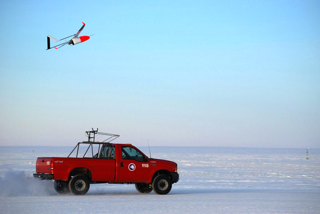
An experiment to make some of the first sustained measurements of atmospheric and oceanic conditions surrounding a polynya in Antarctica yielded not only some interesting results but also set a flight record for unmanned aircraft. John Cassano An assistant professor in the Department of Atmospheric and Oceanic Sciences at the University of Colorado in Boulder Most of the flights lasted from 10 to 17 hours, covering a total of 11,000 kilometers and more than 130 flight hours. “This is really the first unmanned, long-duration aircraft flights in the Antarctic,” Cassano said. The British and Norwegians have also flown UAVs, he said, but those flights were measured in minutes not hours. “These are by far the longest duration flights that have been completed in the Antarctic,” added Cassano, who is also a Fellow of the Cooperative Institute for Research in Environmental Sciences Cassano and his team weren’t just trying to break records with the Australian-made Aerosonde, an aircraft capable of flying into hurricanes and crossing the Atlantic in a single flight. They’re interested in the interactions between the ocean and atmosphere through a polynya (pronounced “puh-LIN-yuhs”). 
Photo Courtesy: John Cassano
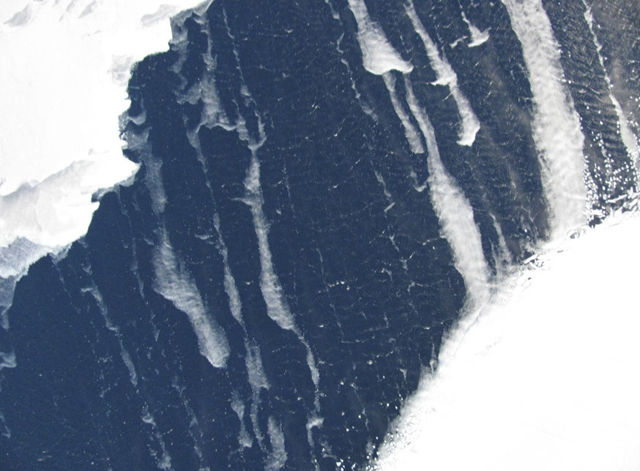
The UAV provides a close-up view of the polynya. Note the white-capped waves.
Polynyas in Antarctica are holes in the sea ice that often remain open thanks to strong winds rushing down from the polar interior. In other regions around the Antarctic, the upwelling of relatively warm water onto the continental shelf can also create a polynya. The recurring one in Terra Nova Bay, huddled against the coast, is about 50 kilometers across. Cassano explained Antarctic polynyas like the one in Terra Nova Bay are important because there are significant exchanges in heat and moisture between the ocean and atmosphere. The interaction even has implications for ocean circulation in the northern hemisphere. [See previous article: Pulse on polynyas.] The scientists wanted to learn more about such things as what processes control the size of the polynya and how the size varies over time. Another question: How does the size affect the exchange of heat and the conditions in the atmosphere overhead? “We needed long-duration aircraft to do the science we were interested in,” Cassano explained. In a blog he wrote for the San Francisco-based museum, The Exploratorium, Cassano said in September that the weather the team had observed at Terra Nova Bay had been nothing short of amazing. “On yesterday’s flight we flew through hurricane strength winds as strong as 90 mph. The wind was so strong that one of the planes came back with a coating of salt on the wings. We think this salt was from sea spray over the open water in the polynya. This is really quite impressive, since we never flew lower than 300 feet above the surface. I can’t even imagine what it must be like to be in an environment where the temperature is below 0 degrees F, the wind is blowing at hurricane strength, and the air is filled with sea spray hundreds of feet in the air.”
The press conference included two other Boulder-based researchers — Elizabeth Weatherhead and Ute Herzfeld, both associated with CIRES — who also discussed the use of unmanned vehicles for exploring the poles. Weatherhead noted that the UAVs add a new dimension of safety to polar fieldwork. “Hopefully the worst we’re going to have with our unmanned aircraft is we lose a vehicle or two,” she said. Indeed, Cassano’s team lost one of four Aerosondes early in the month-long project. He said that otherwise the planes, which have about a three-meter-wide wingspan, performed superbly. In addition to various meteorological measurements, the UAVs returned with high-resolution images of the polynya far superior to any by satellite. In one image from the press conference, white-capped waves were visible. “We can look at sea ice properties by looking at these photographs and combining them with meteorological measurements we were making,” Cassano noted. “They are fairly robust aircraft.” NSF-funded research in this story: John Cassano and James Maslanik, University of Colorado at Boulder, Award No. 0739464
|


For USAP Participants |
For The Public |
For Researchers and EducatorsContact UsU.S. National Science FoundationOffice of Polar Programs Geosciences Directorate 2415 Eisenhower Avenue, Suite W7100 Alexandria, VA 22314 Sign up for the NSF Office of Polar Programs newsletter and events. Feedback Form |


