|
CrackedRift spotted in Pine Island Glacier Ice Shelf before upcoming expeditionPosted October 26, 2011
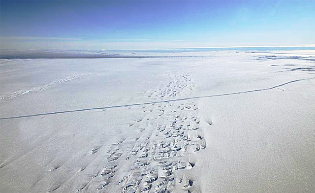
A large crack has been spotted in the Pine Island Glacier Ice Shelf in West Antarctica, threatening to break loose in what scientists believe is part of the natural cycle of calving in a region of Antarctica undergoing profound changes. The crack was seen and photographed on Oct. 14 by scientists aboard NASA’s DC-8 The six-year airborne campaign, which this season includes the National Science Foundation’s Many of the flight lines retrace previous ICESat-1 tracks or future ICESat-2 tracks. Some also align with current observations made by the European Space Agency’s CryoSat-2 satellite The Oct. 14 flight had taken advantage of a rare, cloud-free window over the Pine Island Glacier region. The glacier that terminates into the ice shelf is one of the fastest flowing in Antarctica, and scientists are concerned about its future contributions to sea level. The National Science Foundation (NSF) is supporting a land-based expedition to the ice shelf this season, led by Robert Bindschadler The crack in the ice shelf is about 15 kilometers north of where the team plans to put its first camp, where researchers will drill through about 600 meters of ice so they can put instruments into the ocean cavity below. They want to learn more about the dynamics between the ice and seawater that is thinning the ice shelf, which allows the glacier to flow faster to the ocean. [See previous articles: Cracking the case and Dress rehearsal.] “It looks like a significant part of the ice shelf is ready to break off,” wrote Michael Studinger, Operation IceBridge project scientist, in a brief report following the DC-8 flight. The main goal of that particular flight mission was to get a more detailed picture of an area around the grounding line, where the glacier begins to lift off the bedrock, which is located below sea level. The data from the flight was also collected to support the upcoming land expedition by overflying a number of planned field sites and traverse lines, according to Studinger. “During the last line, we noticed a large crack in the Pine Island ice shelf that spans the entire ice shelf,” he said. Bindschadler had previously calculated the propagation of earlier iceberg-releasing cracks at less than 50 meters per day. This crack must have moved much faster across the ice shelf, he said via e-mail. “The characteristics of the PIG crack that I find surprising are the fact that it is so far across the ice shelf after not having been observed up until the end of last season,” he said. The location of the crack is near where past rifts have appeared in the ice shelf, according to Bindschadler. He estimated that a new, “rather large” iceberg will probably form in the coming months, if not weeks. “I hope that our field team will have enough time to get onto the ice shelf and set up GPS receivers before the calving event,” Bindschadler said. “We’d like to measure if the ice shelf notices the loss.” Ted Scambos “These are cyclical, occurring every few years, very similar in size and even shape,” said Scambos via e-mail. “As a cyclical process, they are not part of the real climate-change/ice-shelf disintegration story.” In 2002, the Larsen B Ice Shelf
“If something different happened this time; for example, the pace of calvings changed, or this one was farther upstream from the past ones, then it might signal some major change in the Pine Island system,” said Scambos, adding that the area is changing in other ways, but the rate of calving has been steady over the last few decades. The DC-8 was scheduled to make another flight on Sept. 26 to the PIG region to gather further data on the ice shelf and crack. |


For USAP Participants |
For The Public |
For Researchers and EducatorsContact UsU.S. National Science FoundationOffice of Polar Programs Geosciences Directorate 2415 Eisenhower Avenue, Suite W7100 Alexandria, VA 22314 Sign up for the NSF Office of Polar Programs newsletter and events. Feedback Form |


