The First Wave of the "Thwaites Invasion"Researchers Travel to the Glacier of Greatest ConcernPosted March 18, 2019
The U.S. and U.K.-funded International Thwaites Glacier Collaboration (ITGC) officially kicked off its science field research in January, when four researchers and their support teams set foot on a remote, fast-melting glacier in West Antarctica, establishing a beachhead for an unprecedented international project to determine the glacier's fate. 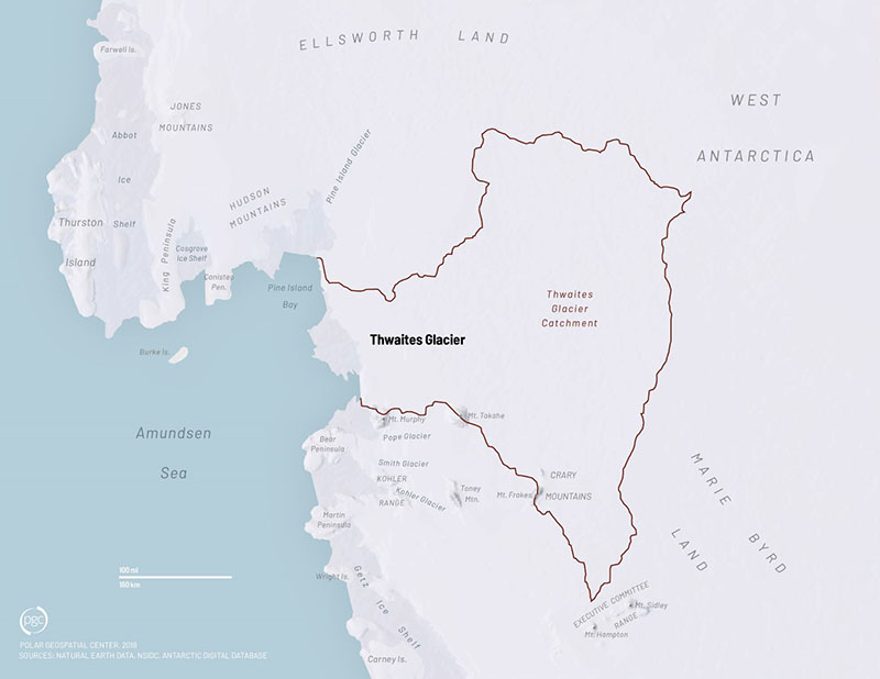
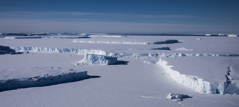
Photo Credit: The Polar Geospatial Center
The Thwaites Glacier is a vast expanse of ice in West Antarctica, covering an area about the size of Florida.
They were part of an enormous effort over the next five years to collect previously unavailable data on the largest glacier in West Antarctica, which glaciologists fear is in danger of a massive collapse, though exactly when—in a matter of decades or centuries—is a major question mark. They traveled to the remote Thwaites Glacier to find safe campsites, scout landing strips, test some of their scientific equipment and take some preliminary data. "We definitely met all of our first-order objectives," said Kiya Riverman, a glaciologist at the University of Oregon. "We established that that area is possible to work in and safe to work on, so it opens the door to this huge project that's been planned for next year and beyond." In the coming years, a total of six joint U.S. and British research teams will travel to the region by land, sea and air to learn as much as they possibly can about the Thwaites Glacier. Two additional projects will use these data in new modelling studies of the evolution and potential future of the region. These projects are supported by the National Science Foundation, which manages the U.S. Antarctic Program, and the Natural Environment Research Council, which operates the British Antarctic Survey. The combined science effort, including meetings, discussion, outreach and supporting data, is being facilitated by the ITGC Science Coordination Office. 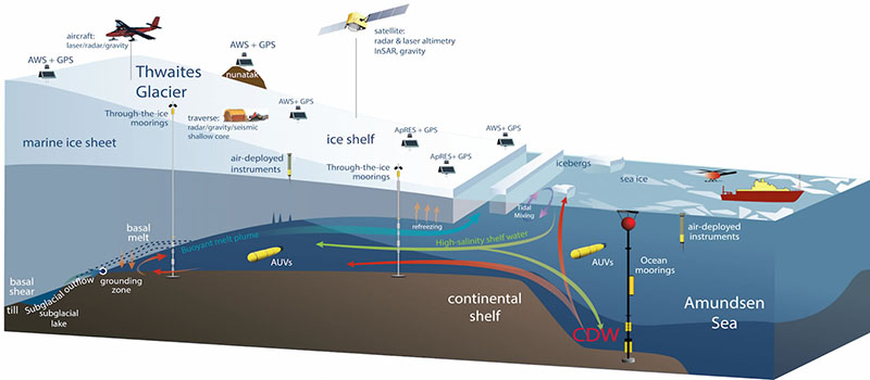
Photo Credit: The International Thwaites Glacier Collaboration
Over the next three years, researchers will study the Thwaites Glacier from land, sea, and air.
Thwaites is the PlaceThe Thwaites Glacier is an expanse of ice about the size of Florida on the coast of West Antarctica along the Amundsen Sea Embayment. Satellite data show that this is also one of the fastest melting regions of the Antarctic and could be in danger of a massive collapse in as few as two centuries. "Because Thwaites is such a large glacier [and is] largely on land, if it continues to melt or break apart, the parts that are on shore will contribute to sea level rise," said Marianne Karplus, a seismologist at the University of Texas at El Paso. "It's a glacier that's considered to have a very high risk of contributing a large increase to sea level rise." Should it crumble, the water released into the oceans by it alone could increase sea levels worldwide as much as three feet and could possibly lead to the collapse of other nearby glaciers as well. The researchers on the collaboration want to understand as much as possible about this glacier to better pin down its likely fate as well as the fate of others. "For an even broader perspective, narrowing in and zooming in on one glacier will help us understand other glaciers, and other glacial processes." Karplus said. "It'll help us better understand how glaciers behave and how they behave depending on various possible scenarios for changing climate, and what the environment is like for them in the future." It's a major collaborative effort by the U.S. and British programs and one of the largest joint efforts ever to study a single glacier. Each international team is focused on understanding a different aspect of the glacier’s behavior, ranging from its distant past to its near future. This first deployment encompassed the following projects: 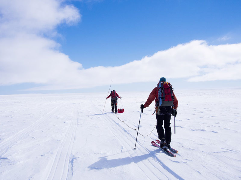
Photo Credit: Kiya Riverman
The two mountaineers that traveled with the MELT team help lay seismic cables.
MELTing Down?Kiya Riverman is part of the MELT project, led by David Holland of New York University and Keith Nicholls of the British Antarctic Survey. They're studying the line where the glacier's ice comes into contact with the ocean, called the grounding zone. "We're interested in how the ocean is melting the ice in this really key zone," Riverman said. "The way we're going to be doing that is by drilling holes through the floating ice and then installing oceanographic instruments in the ocean cavity below, as well as putting gliders down there, and from the surface taking measurements actually of what melt rate is." Glaciers can melt from below the bottom up as much as they do from the top down. When warm ocean waters seep under the ice, it can thin out their undersides dramatically. In recent years scientists have become increasingly concerned about the destabilizing effects that warm ocean water can have on Thwaites and other glaciers. "Antarctica is ringed almost entirely all the way around it by this deep warm ocean current called Circumpolar Deep Water, and in places that water is able to make its way up onto the continental shelf. It's able to get close to glaciers," Riverman said. "When that warm dense water comes into contact with ice, the ice melts, and the [melted] ice then freshens [the circumpolar deep water] so then it rises within the water column and then along the way melts even more along the underside of the ice." 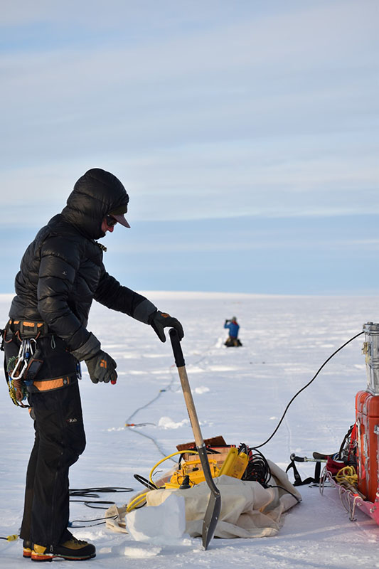
Photo Credit: Kiya Riverman
Glaciologist Kiya Riverman prepares to install seismic listening devices in the snow to map the terrain far below the ice.
Scientists think that because of this seeping warm water, there lies beneath Thwaites a topographic ticking time bomb. The bedrock ridge at the front of the glacier slopes away from the grounding zone, deepening toward the center of the ice sheet. If the warm ocean water melts the ice at the grounding zone and laps over the subglacial ridge holding back the ice, it could, in effect, be breaking the seal. Relatively warm seawater would then start working slowly down the far slope of the ridge and melt vast areas the glacier base, thinning it and triggering faster ice flow. As more of this warmer water pours in, the thinning ice begins to float, further speeding up how fast it flows into the ocean. "It means that there can be this really catastrophic loss of ice, just based on the fact that as you step your ice-ocean boundary backwards, the speed at which ice flows out is going to be increasing," Riverman said. "It's a positive feedback." Over the next three years she and her team will drill down through the glacier's 600-meter thick ice, into the ocean cavity below, to deploy oceanographic instruments and measure ocean conditions and melt rates on the underside of the ice. They'll also take seismic surveys to track how fast the underside is melting. 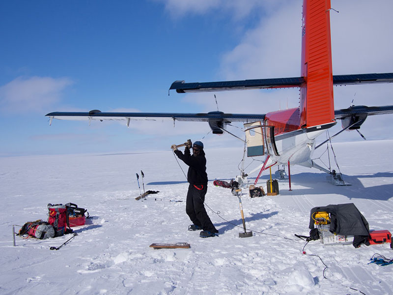
Photo Credit: Kiya Riverman
Glaciologist Sridhar Anandakrishnan hits the surface of the ice with a hammer to send seismic waves through the ground and calibrate the MELT team's instruments.
"No one has ever looked at the ocean beneath Thwaites's floating tongue before so this is going to be the first observations of what the shape of that cavity looks like," Riverman said just before flying to the region. "The shape of it and the configuration of it has so much of an impact on the long-term stability of the system. This is the first order geometry that we need to know in order to understand why the system is changing now and how it might change in the future." This season Riverman flew to the region to scout where precisely the grounding line is and where would be best to drill. "We did kind of this preliminary survey of how thick is the ice? and how thick is the ocean? and what's the shape of the ocean cavity?" Riverman said. After landing at their campsite, Riverman and her teammate, Sridhar Anandakrishnan of Pennsylvania State University, spent several days traveling up and down the glacier with their seismic equipment looking for the grounding line. Using a kind of seismometer called a geophone, she and her teammate listened to the vibrations within the ice to map out the landforms underneath the ice. 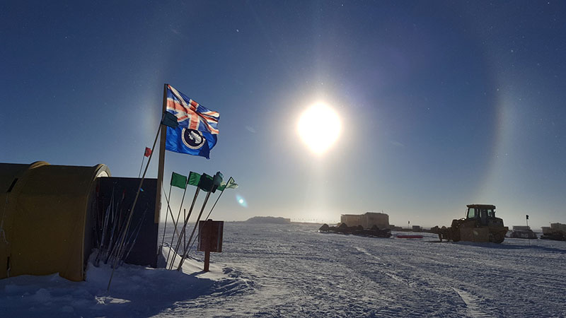
Photo Credit: Marianne Karplus
The WAIS Divide field camp will act as a staging area for teams flying to the Thwaites Glacier.
"We laid out lines of seismic cables, then dug in the geophones and detonated explosives," Riverman said. "The energy went into the ice and it reflected off the bottom of the ice and then traveled through the water and reflected off the sea floor." From the echoes of those explosions, they were able to reconstruct the topography underneath the ice and pinpoint exactly where the glacier’s grounding line is. "Knowing where we can drill through the ice given constraints of how thick the ice and water have to be for the instruments that we want to put down in there," Riverman said. "We now know the geometry of that system so we can say ‘ok let’s go drill our holes at this point.'" It's About TIMEMarianne Karplus and her teammate Galen Kaip, also a seismologist at the University of Texas in El Paso, flew to the glacier in part to scout out spots for their upcoming project, and to field test out their own seismic setup. 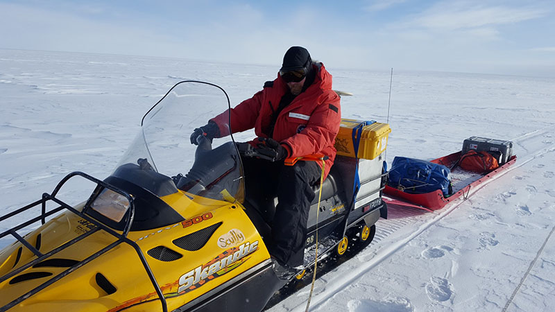
Photo Credit: Marianne Karplus
Seismologist Galen Kaip with the TIME research team, prepares to ride out to their testing area with his seismic equipment in tow.
They're part of the project called TIME, or Thwaites Interdisciplinary Margin Evolution. Led by principal investigators Slawek Tulaczyk of the University of California, Santa Cruz and Poul Christofferson of Cambridge University, the team is investigating the ground conditions underneath the glacier and its shear margin, the area where the ice of a fast-moving glacier abuts the ice of a neighboring, slower moving ice mass. "The studies that we're doing will help us better understand the processes at the margin, and we'll also be getting basic characteristics of things like the thickness of the ice [and] how fast is it moving," Karplus said. "There exists satellite data from that area, but not a lot of GPS stations on the ground looking at how the ice is moving across the margin, or even exactly where that margin even is." Glaciers are often described as flowing rivers of ice, but it's not always clear why one region is flowing faster than another. In part, it has to do with the conditions at the bed of the glacier, where the ice contacts the ground below. If the glacier is moving over a thin layer of water or hard dry bedrock or fine damp dirt, it may move faster or slower. 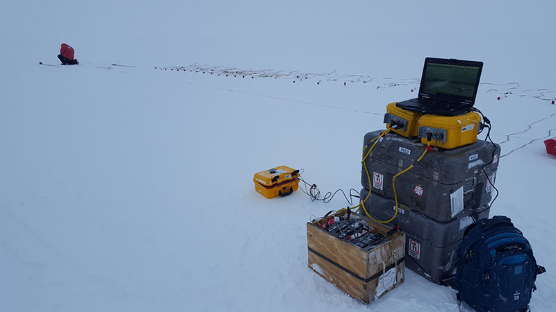
Photo Credit: Marianne Karplus
Seismologist Galen Kaip lays a line of seismometers to listen to the echoes of their explosive charge.
"Understanding those kinds of processes and how the margin is behaving will help us to better understand whether something could happen, like [if] the margin could move significantly," Karplus said. Scientists worry that the edge of the fast-moving glacier isn't fixed and could move in or out if conditions change. The worst-case scenario is the edge could suddenly expand farther out into ice that isn't moving as swiftly, effectively increasing the size of Thwaites and the volume of ice flowing into the ocean. But it may also be possible that the shear margin could also snap inwards, shrinking Thwaites. They're just not sure which might be more likely and need more data to know. Over the next three years the team will return to the glacier and deploy a number of GPS stations around this border, known as its shear margin, to track its edges and how fast it's flowing along the neighboring glacier. "We'll have one GPS site on either side of the margin, at six different locations, so 12 GPS stations positioned across where satellite data shows us where the shear margin is," Karplus said. They'll also be conducting seismic surveys of the ground beneath the ice. Using an innovative grid of seismometers and small explosives, they'll be able to take an accurate picture of the ground below. 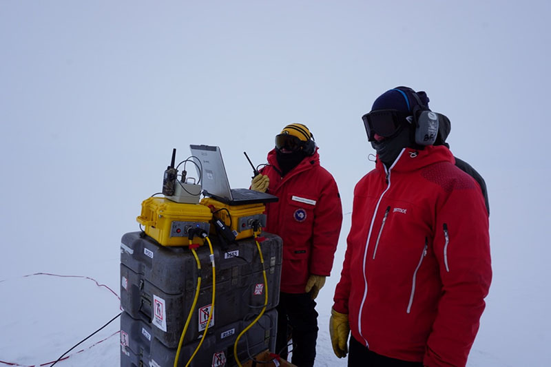
Photo Credit: Aurora Roth
Seismologists Marianne Karplus and Andrew Lloyd prepare to detonate an explosive charge.
Historically, most seismic surveys in Antarctica have been arrayed in one single line, giving a cross-section of data just below the line of sensors. The TIME project will deploy grids of sensors, which should give a more complete, three-dimensional image of the ground below. It takes a lot of effort to drill and deploy the number of seismic monitors needed for a 3-D survey, so the team is also testing out ways to make the process less labor-intensive. "What we're doing this year is kind of a small, pilot project," Karplus said. "Because we're doing something kind of new, especially with the 3-D seismic surveys in trying to cover a grid instead of just a line, we're looking for a technique that is able to do the imaging, but we can do it quickly and we can do it at a lot of different locations in the grid." This season Karplus and her team traveled to a field camp in the middle of the West Antarctic Ice Sheet to test out their seismic system. The camp, known as WAIS Divide, is about 300 miles from Thwaites's grounding line, and will be the primary staging point for traveling to the glacier in the upcoming years. At a safe, five-kilometer distance from WAIS Divide, the team tested their explosives and seismometers. "We tested a number of different types of seismic sources and configurations and it seems like we got really good data so far," Karplus said. 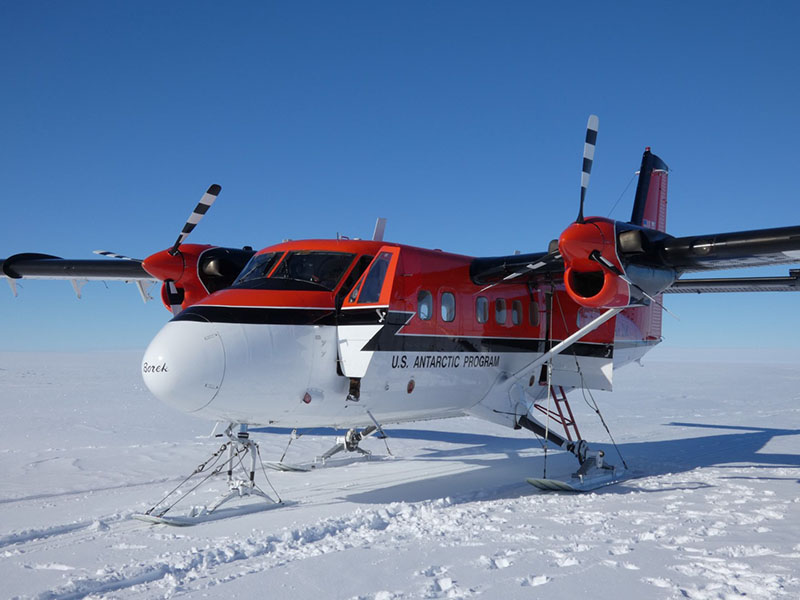
Photo Credit: Marianne Karplus
In addition to testing their seismic systems, Marianne Karplus and Galen Kaip flew a reconnaissance mission to the site of their future campsites.
Now back in the United States, the team is processing their data to see what type and configuration of explosives worked best. "They all looked pretty good, but you can't see those kinds of details at the scale of just looking at the initial data," Kaip said. "There's a lot more work to go, but the shots all went well." In the coming field seasons they're also planning on using radar and passive seismic systems to collect more information about the shear margin and glacial bed. NSF-funded research in this story: Slawek Tulaczyk, University of California, Santa Cruz, Award No. 1739027; David Holland, New York University, Award No. 1739003; Ted Scambos, University of Colorado at Boulder, Award No. 1738913. |
"News about the USAP, the Ice, and the People"

For USAP Participants |
For The Public |
For Researchers and EducatorsContact UsU.S. National Science FoundationOffice of Polar Programs Geosciences Directorate 2415 Eisenhower Avenue, Suite W7100 Alexandria, VA 22314 Sign up for the NSF Office of Polar Programs newsletter and events. Feedback Form |