Where the Ice Layers GrowScientists hunt for the site of the next deep U.S. ice corePosted July 13, 2020
Hunting for the perfect patch of ice can be a herculean task. Knut Christianson, of the University of Washington, spent three weeks with his research team in a barren and remote part of Antarctica, scouring the landscape for the perfect spot. The researchers think that the region, known as Hercules Dome, can help scientists predict the future of the West Antarctic Ice Sheet, by digging up the secrets of its ancient past. Though this season was anything but easy for the team, the work at Hercules Dome is only just beginning. "This project is the first step in trying to determine whether or not there is a good site for a possible ice core in this location in the future," Christianson said. "The overarching question that this project seeks to answer is what will happen to the Antarctic ice sheet in a shifting climate, particularly in warmer periods." He and his team are hoping to find the perfect location to eventually drill down deep into the West Antarctic Ice Sheet and sneak a peek at the prehistoric climate data embedded below. They want to know how often and to what extent the vast expanse of ice that covers much of West Antarctica melted out and whether current climate trends might trigger another collapse. 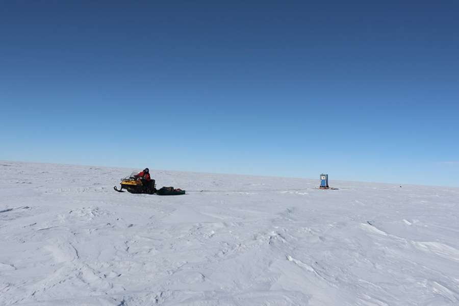
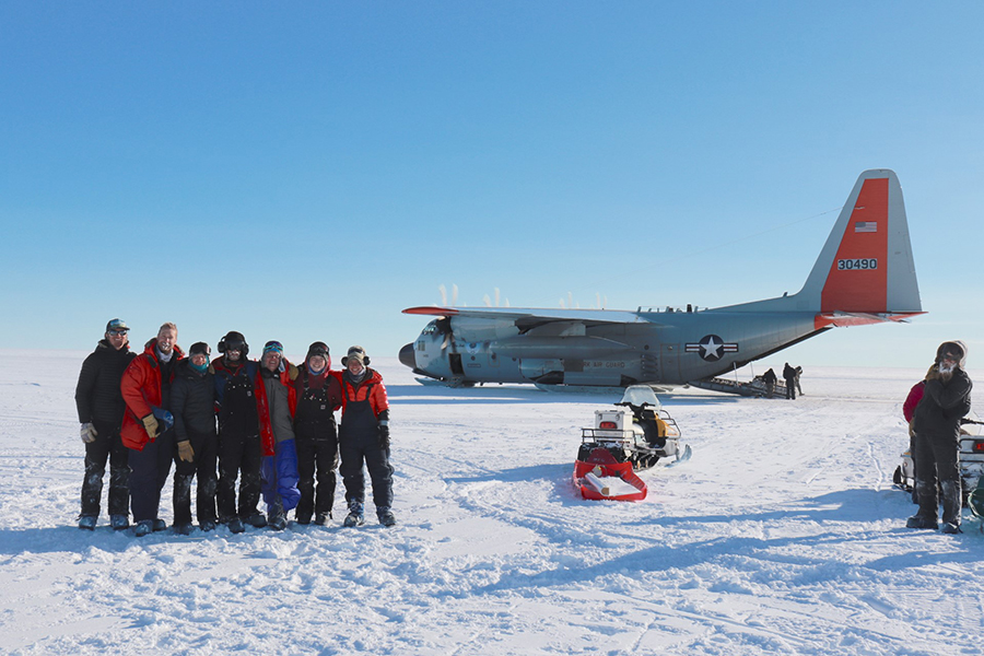
Photo Credit: John Christian
Andrew Hoffman drives his snowmobile across Hercules Dome while Gemma O'Connor operates the radar inside the shelter in tow.
The project is supported by the National Science Foundation, which manages the U.S. Antarctic Program. A Prehistoric Beachfront?Antarctica is divided into West and East Antarctica, separated by the Transantarctic Mountains that bisect the continent. The thick ice sheet of East Antarctica has been around for approximately the last 30 million years. However, studies have shown that the West Antarctic Ice Sheet is considerably less stable and has likely melted out at least once in the past million years, likely more. Pinpointing exactly how many times it has melted and fallen apart during warm, "interglacial" periods has been difficult. Past collapses, possibly as recently as about 125,000 years ago, as well as the normal flow of the ice sheet into the sea, likely have erased all of the older ice layers and associated historical data with it. There are ice cores that extend as far back as 800,000 years on the far side of the continent, at spots in East Antarctica, but they're so distant they don't contain much meaningful data about West Antarctica. "We're talking about a distance [equivalent to] across the continental U.S. and a vastly different elevation and so it's just too far away to record the climate change that we're interested in," Christianson said. "This project is focused on finding an area where it would have very likely remained glaciated during the last interglacial, even if the West Antarctic Ice Sheet as a whole collapsed, but would have felt the climate change." Hercules Dome is at the tip of the Transantarctic Mountains in East Antarctica, more than 650 miles from the present-day coastline. Researchers think it could be the ideal location to get a glimpse at what may have happened 120,000 years ago during a time called the Eemian interglacial period, a time when global climates were slightly warmer than today and glaciers and ice sheets likely retreated. "It would be beachfront property if West Antarctica collapsed," said Gemma O'Connor, a graduate student at the University of Washington. "It's unclear if West Antarctica actually did collapse during the Eemian Period. The theory is that Hercules Dome's climate would have sensed if West Antarctica did collapse… If West Antarctica wasn't there, then that would have caused a big change in atmospheric circulation that we could sense in the water isotopes and probably other things in the ice core." "Hercules Dome is sort of right at the balance between the two ice sheets where the ice should be preserved but it's close enough to West Antarctica that it gets a good signal of West Antarctic Ice Sheet collapse during the Eemian Period," said Benjamin Hills, a graduate student at the University of Washington. "This project is a reconnaissance for the ice drilling, so we're going to go out there to do geophysics, mostly ice-penetrating radar, to survey the dome itself and choose the preferred location to drill." A Dome of IceDomes are the ideal places to drill an ice core to peer into the distant past. Though a block of ice might seem rigid, vast sheets of ice flow very gradually. Glaciers are slow-moving rivers of ice, and over thousands of years a hunk of ice can travel vast differences as part of these highly viscous streams. 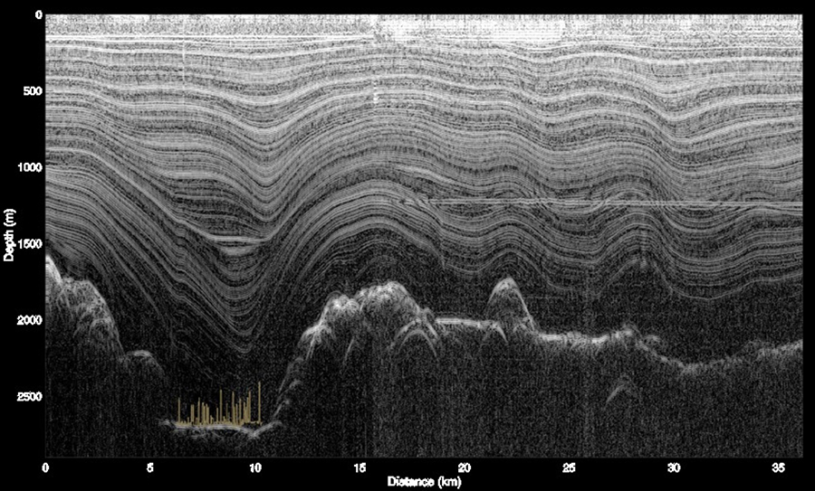
Photo Credit: Andrew Hoffman
Radar profiles unveil the landforms and layers of ice below the surface of Hercules Dome with a representation of the Seattle skyline added in the lower left for scale.
Much of this flowing ice originates in domes. Snow precipitates out of the sky and accumulates on the ice sheet surface. Over time subsequent snowfall builds up on top, which compresses the initial snowfall more and more until it fuses to make glacial ice. At a dome, this compression just pushes the ice straight down rather than off in any particular direction, cleanly preserving the layers without warping them. Sometimes instead of a single point at a dome, the ice pushes down along a line, which is called an ice divide. "We want somewhere where the ice flow is very simple," O'Connor said. "It's just simplest to drill an ice core in a place where we know that snow hasn't come from somewhere else. We know we're getting a record of exactly one constant in space as opposed to sampling an ice core where the ice has been flowing from somewhere kilometers upstream that gives us a mixed signal of the climate. We want to keep it as simple as possible." These ice layers are like time capsules of ancient climate data; the deeper down one goes, the older the ice gets. Embedded within the ice is a wealth of data including what ancient atmospheric conditions were like, what weather patterns may have been, how much precipitation fell, and how they've all changed over time. "We know that the West Antarctic Ice Sheet has collapsed in the past at some point, but the timing of that is what isn't really well constrained," Hills said. "So it's a big open question as to how sensitive it is intrinsically and whether it collapsed during every interglacial over the last two million years or if it only happened once or twice and really the last one is the one that we want to know about." How sensitive the ice sheet is, and how much the climate needs to warm to trigger a collapse, is a question that's more salient than ever as the Earth continues to warm. Christianson and his team are, in effect, looking back at the past for insights into what the future might hold as the Earth enters a new warmer period. "This hopefully will give us information about whether West Antarctica collapsed fully or not," said Annika Horlings, a graduate student at the University of Washington. "That's important because right now a lot of uncertainty sort of remains in future projections of what will happen to the West Antarctic Ice Sheet." Other geologic research has shown that the Eemian Period was marked by a warmer than average climate for the time, conditions that current trends are starting to mirror. "The ice sheet back in the Eemian was the same size and shape it is today, when it entered that warm period, and then it decreased in size and shape," Christianson said. "The forcings might be different, but there will be some similarities in how the ice sheet reacts." If the ice sheet collapses, even only partially, that's a tremendous amount of ice that will go into the planet's oceans, causing sea levels to rise around the globe. It's estimated that West Antarctica contains about 2.2 million cubic kilometers of ice, which if the entire ice sheet goes, could lead to more than three meters of sea-level rise around the globe. Cities on the coasts will be the most directly impacted, but the social and economic impacts will likely reverberate throughout the planet. "Sea levels are going to rise so as it gets warmer you're going to have more ice loss," Christianson said. "That will affect economies which will affect lifestyles on large scales, and so we would like to know how to best adapt and mitigate those changes with requiring the least amount of money and the fewest changes in peoples' lives. So if we can give you an accurate assessment of how much sea level to expect from Antarctica in the next 100 to 500 years, that provides things that are actionable that planners can use." Hunting the Perfect IceChristianson and his team spent about three weeks camping out on Hercules Dome, using ice-penetrating radar to scour the region for the ideal spot for a future ice coring site. 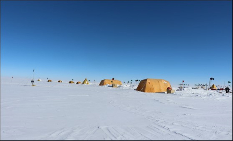
Photo Credit: Gemma O'Connor
The camp at Hercules Dome where the team spent three weeks collecting their radar data of the region.
"We were looking for an area where we can find an ice divide," Christianson said. "But an ice divide today may not have been an ice divide in the past 150,000 years, so we really need to then go and use the radar to look at the internal structure and see whether the internal layers are consistent with there being an ice divide that has been in this approximate location for a very long time." They brought along six types of radar to take detailed snapshots of the ice near the surface, and to peer all the way down to the bedrock through nearly three kilometers of solid ice. With their radars strapped to the back of their snowmobiles, they drove across the frozen landscape, pinging the ice and collecting lines of data showing the unseen structures below the surface. With constant below-zero temperatures and at nearly 3,000 meters of elevation in some spots, it was not easy going. "Nothing likes to work in the cold. Everything gets more difficult. All the electronics are less cooperative, you have to be more careful because you really can't be uncovered out there for any length of time," Christianson said. "The roughness of the surfaces just beats up Skidoos, beats up equipment, the difficulty of getting generators started in the cold, the electronics working in the cold… it all adds up to make things take longer." Despite these hardships, the team was able to collect more than 600 kilometers of deep radar data, 300 kilometers more of shallow data and visited more than 50 sites to take point measurements of the ice motion in three dimensions. "With this data, we already think we've identified two sites that are favorable locations. Not going to say optimal but they're promising," Christianson said. "We have another field season and during this last field season we hope to fill in the one area we have not surveyed." These field seasons are just the beginning of work planned for Hercules Dome. In the coming years, this remote location will become a hub of activity as researchers and technicians plan to travel to the region to drill deep into the ice and recover ice cores and climate data from 120,000 years ago. "The eventual goal within the next decade would be to drill a deep ice core, the next large American-led core," Christianson said. "Once it starts it could take three or four years of successful drilling." This planned ice coring operation is a major undertaking, likely requiring many tons of equipment transported into the remote area and dozens of people working to extract what will be the deepest continuous ice core that samples West Antarctic climate. "Deep being more than a kilometer, the ice gets up to about two and a half kilometers thick in this area," Hills said. "The next deep U.S. ice core will be drilled at Hercules Dome." 2019-2020 Field Team: Vito Cicola, John Christian, Knut Christianson, Benjamin Hills, Andrew Hoffman, Nick Holschuh, Annika Horlings, Gemma O'Connor, Shannon Wilson Hercules Dome Project Team: Jessica Badgeley, John Christian, Knut Christianson, Howard Conway, Maurice Conway, Lindsey Davidge, Marina Dütsch, T. J. Fudge, Benjamin Hills, Andrew Hoffman, Nick Holschuh, Annika Horlings, Gemma O'Connor, Eric Steig NSF-funded research in this story: Knut Christianson, University of Washington, Award No. 1744649. |

For USAP Participants |
For The Public |
For Researchers and EducatorsContact UsU.S. National Science FoundationOffice of Polar Programs Geosciences Directorate 2415 Eisenhower Avenue, Suite W7100 Alexandria, VA 22314 Sign up for the NSF Office of Polar Programs newsletter and events. Feedback Form |