An Aerial Assessment of Adélie PenguinsScientists Count Penguins with a Swarm of Flying RobotsPosted November 30, 2020
Flying robots are helping scientists track the population of Adélie Penguins. This past austral summer, researchers flew a small fleet of coordinated unmanned aerial vehicles, or “UAVs,” over Cape Crozier, one of the largest Adélie penguin colonies in the world, photographing it in greater detail than ever before. 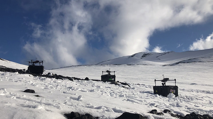
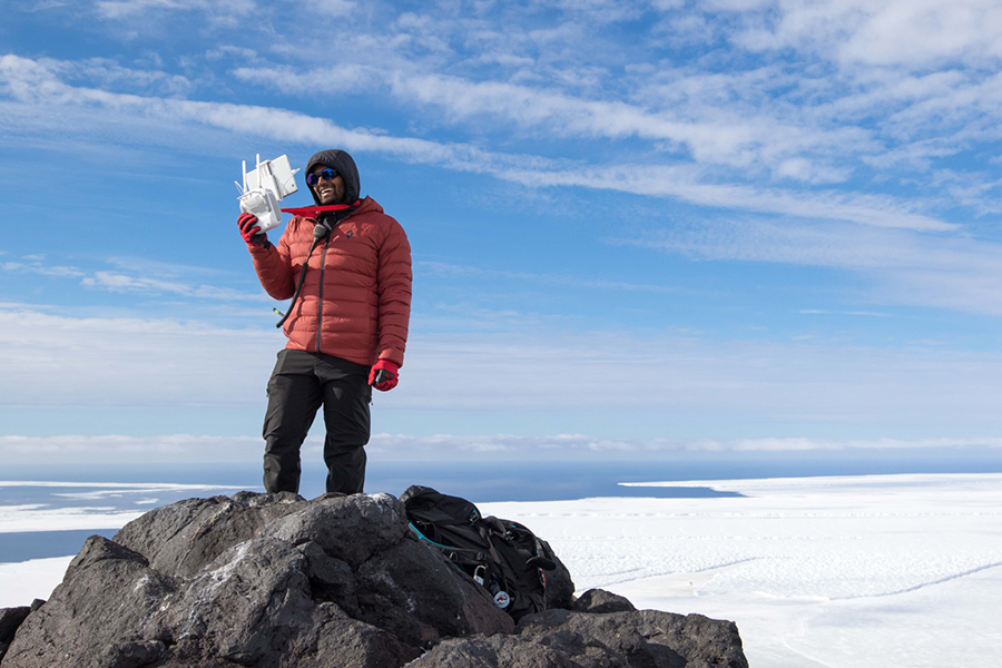
Photo Credit: Parker Levinson
Three AUVs perched atop their carrying cases, ready to work together to map the Cape Crozier Adélie penguin colony.
Part of the team has returned to Antarctica for a follow-up census, while others are now in the process of stitching together those thousands of high-resolution images and developing a way to count the birds using a learning algorithm. Their hope is that by using this technique they can get an accurate count of the number of birds in the colony, and gain more insights into how Adélie penguins interact with their environment. “They are a key sentinel of climate change because they are completely dependent on frozen oceans, the sea ice,” said Grant Ballard, chief science officer at Point Blue Conservation Science and principal investigator on the project. “Knowing how many Adélie penguins there are is a really important monitoring tool.” The research is supported by the National Science Foundation, which manages the U.S. Antarctic Program. How to Count PenguinsCape Crozier is one of the biggest Adélie penguin colonies in the world. Home to an estimated 600,000 penguins, the colony is located on the far side of Ross Island, about 70 miles from McMurdo Station. 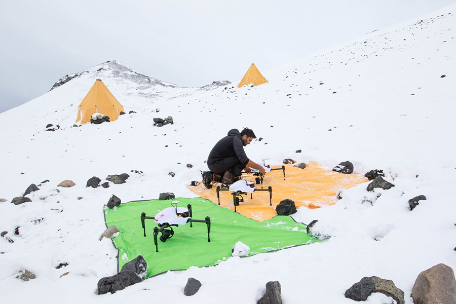
Photo Credit: Annie Schmidt
After a recent snowfall, Kunal Shah preps three of the team's AUVs before a mapping flight over the colony.
Getting a precise count of the birds is difficult. For years, research teams have kept a census of the penguins that nest there by doing ground counts. They count the number of nests and chicks in representative sections of the colony and compare it to aerial photos taken from helicopters, but this method is less accurate for larger colonies. Ballard and his team are hoping to streamline the process. Between November and January, the team flew eight UAV operations over Cape Crozier and two over the nearby colony at Cape Royds, using their quadcopters to take thousands of high-resolution images of the nests below. The team then stitched the geo-tagged images together to make their detailed maps of the colony. “At a basic level, counting animal populations is still very hard. We are always trying to figure out ways to do that better and more accurately,” said Annie Schmidt, the Antarctica program leader at Point Blue Conservation Science. “What's unique about this is being able to not just count, but having the numbers spatially referenced so we know that in this part of the colony there were this many birds and then there are this many chicks in that part. We've never had that kind of information before. That will give us a lot of power to analyze information from that specific spot and how that influences the penguins. Ultimately we'd like to scale this to potentially other places and other colonies that are hard to survey because they're so large.” Birds in the colonies are continually moving around, so the number of birds actually present in the colony at any given moment is constantly changing, making a precise count hard to pin down using ground-based, slower methods. Weather and the time of the season also affect how many birds might be present in the colony, so to get a precise count the team was eager to find a way to take a quick and detailed snapshot of the whole colony. Using a swarm of up to four drones, the team was able to capture a snapshot of the whole colony in only three hours. It's a big improvement over the previous year when the researchers brought down a single drone, and flew it manually, which took three full days of flying to cover the whole colony. “It's just very hard to make sure that you can guarantee that you have full coverage,” said Kunal Shah, a graduate student at Stamford University. “You don't really have all these feedback mechanisms to tell you definitely yes, you have the entire colony. Also just manually piloting, it's very hard to keep it regular, like within the grid or even the same altitude, making sure you're tracking the land features.” 
Photo Credit: Annie Schmidt
Researcher Meghan Elrod remote pilots an AUV just after takeoff before sending them on their mapping mission at Cape Crozier.
In the past, the team used aerial photography from planes and helicopters flying next to the colony, as well as overhead satellite imagery. However, there are several drawbacks. So as not to disturb the penguins, noisy helicopters and planes have to stay some distance away from the colony, producing images that are lower resolution and difficult to distinguish each bird. In addition, even in the best quality images, there are just so many birds it's a tremendous task to count them all. “Counting the penguins is actually done by hand, people have to go through and count them. It's very difficult,” Ballard said. “One of the big problems, aside from just the time required to do that, is to know that you've collected a complete set of photographs is almost impossible with the current approach. In other words you can take all the pictures you want, but it is really easy to miss parts of the colonies, epically the very large colonies, and leave basically donut holes or other missing segments.” By having the computer fly the UAVs with automated flight paths based off of GPS coordinates, the team could ensure complete coverage of the colonies. This automation also makes it easier to protect the penguins. The computer is better than a human pilot at keeping the UAV flying exactly 50 meters off the ground, a height that both doesn't disturb the penguins and ensures the collection of good, consistent data. Computers Taking the HelmNow that they have one full season's worth of data, members of Ballard's team are developing computer programs to almost totally automate the counting process. “We're really hoping that we'll be able to feed these images into a machine learning algorithm that will then be able to in relatively short times give us a number from the images,” Schmidt said. 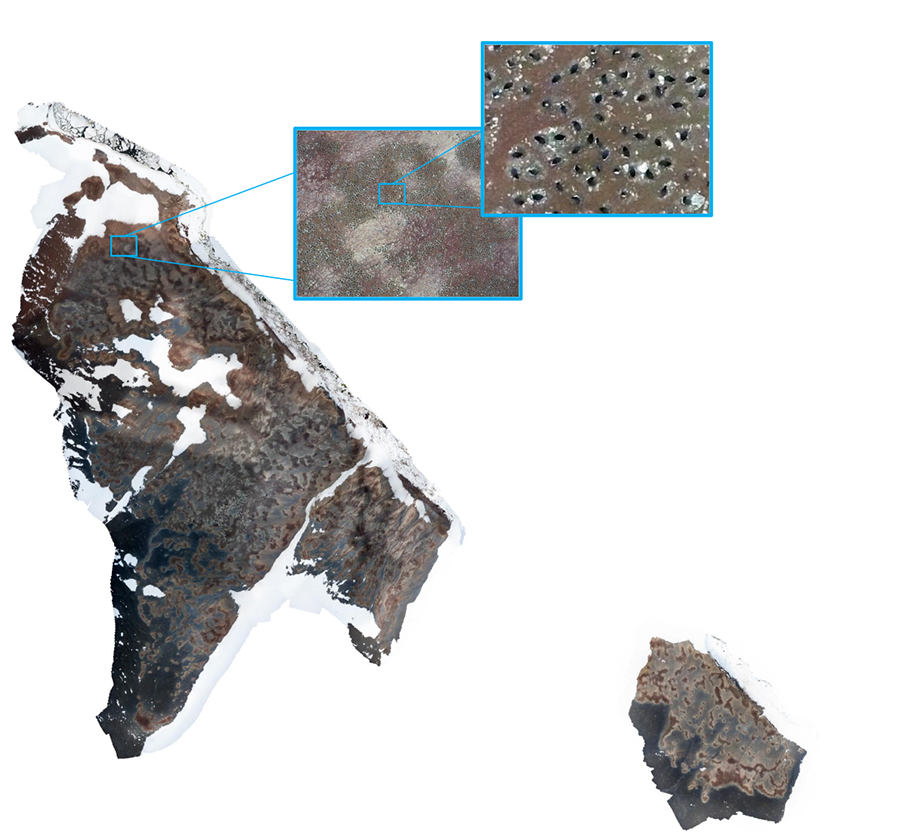
Photo Credit: Kunal Shah
A stitched-together image of the entire Cape Crozier penguin colony, composed of thousands of high-resolution images that can resolve individual birds.
In addition to providing a comprehensive penguin count, the images contain a lot of data about the immediate environment around where the birds make their nests. “Once we get the really high-resolution digital elevation model, we'll be able to characterize the habitat to a really fine scale which we've never been able to do before,” Schmidt said. “We're hoping that will give us a lot more information about how the penguins are selecting their habitat to some extent and also once they've selected their habitat, how that influences how successful they're able to be.” The team is still developing the penguin counting algorithm, but already the project has produced a number of advances that can help other projects using similar techniques produce high-quality data. “The major innovation we've had so far is actually in the math of how you calculate the most efficient path,” Ballard said. Efficiency is the key to getting the most out of the UAVs. Even under ideal circumstances, most commercial UAVs only have enough battery power to fly for at most about half an hour. In the cold environs of Antarctica, chilly temperatures can cause the batteries to expend their charge even faster. “This algorithm will give you a set of paths depending on the type of drone you have,” said Shah who led the development of the algorithm that plans the most efficient UAV path. “It takes the battery limit into consideration and it will give you basically a list of paths that you can fly starting from whatever starting location you want.” The team recently published a paper in Science Robotics on developing the algorithm in hopes that other researchers might be able to utilize this technique. 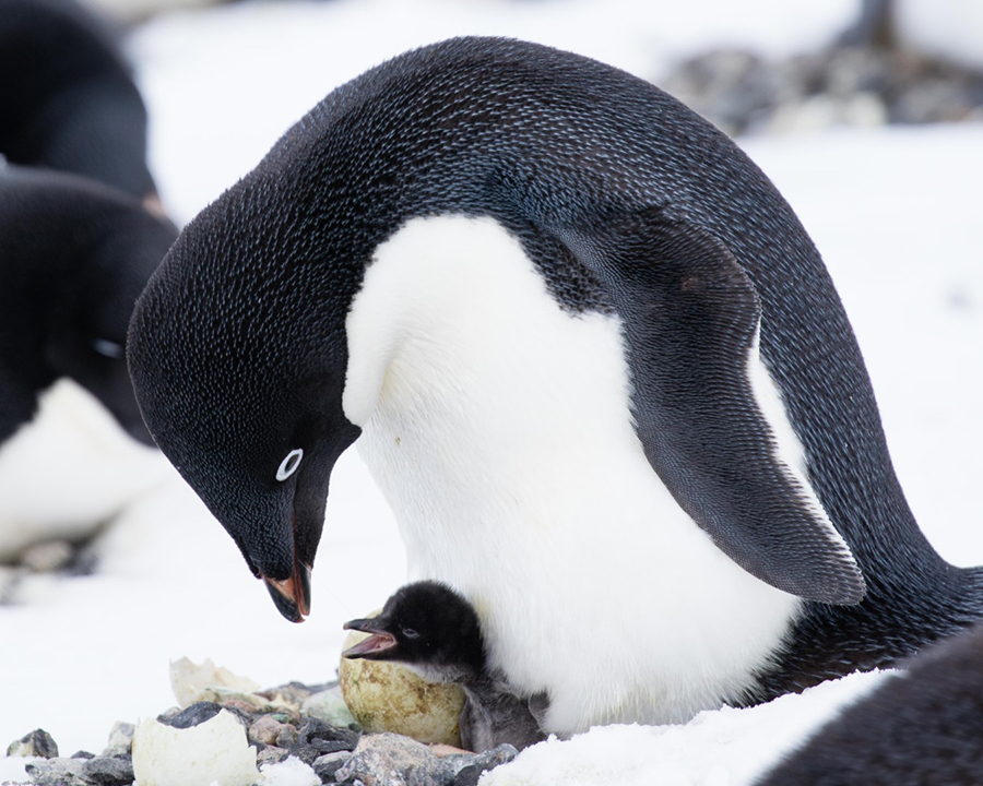
Photo Credit: Annie Schmidt
An adult Adélie penguin stands over its chick to keep it warm. The team hopes to develop a machine-learning algorithm to count all of the penguins and chicks in their all-colony images.
“The whole idea is being able to do these massive land surveys for plants and animals, really anything at scale with lots of drones as fast as possible,” Shah said. Learning the Ways of the PenguinsWhile members of the team in the United States continue to refine their counting algorithms, Ballard and Schmidt recently returned to Cape Crozier to continue their work and collect another season's worth of data to start to compare the colony throughout the austral summer over multiple years. “One of the things that I'm excited about is not just having one picture but having multiple pictures of the habitat throughout the season,” Schmidt said. “We see in the beginning it's really cold, everything's frozen, nothing's moving, but then by the end of the season when there's lots of water running, we start to see some erosion too. That's another dynamic feature that we haven't been able to quantify before.” One mystery the team is particularly interested in solving is about how the Crozier colony continues to grow. Over the last two decades, the colony keeps getting bigger, even though research done around the turn of the millennium indicated that the nearby environment couldn't support many more penguins. “We basically said this colony can't get any bigger because they're eating all the food that's available within the foraging range of an Adélie penguin… But then subsequently the colony doubled in size,” Ballard said. “There's this idea in ecology about density dependence and in theory there should be a limit to how big a colony should get and how dense it can get and Cape Crozier is breaking the rules as far as we understand them.” They have a couple of theories that could explain why this might be ranging from changing ice conditions from a warming climate to the overfishing of one of the chief competitors. “One hypothesis is that for some reason there's more prey available in that area now than there used to be, and that could be because of changes in the ice,” Ballard said. “Another potential explanation that's not necessarily mutually exclusive is that because [Antarctic] toothfish were removed—toothfish compete with Adélies for the same prey, especially silver fish—potentially there are more silver fish because there are less toothfish and that made it easier for the Crozier penguins.” 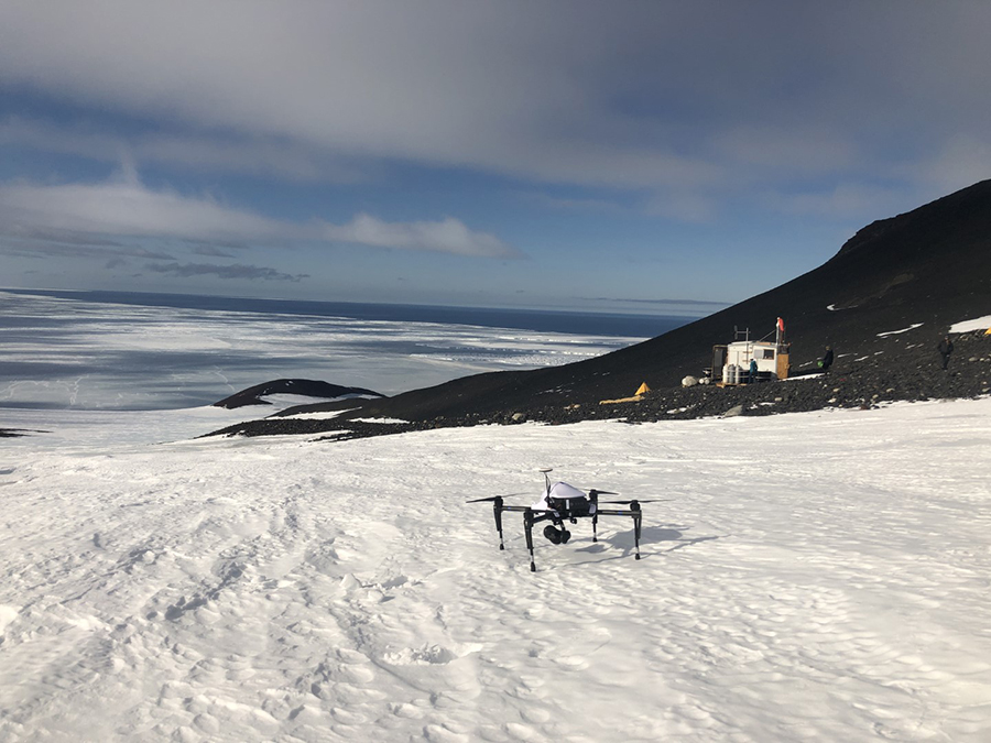
Photo Credit: Parker Levinson
At the Cape Crozier camp, an AUV sits out ready to go on a mapping mission of the penguin colony.
These kinds of environmental and ecological changes are happening all around Antarctica. Adélie penguins can tell researchers a lot about how the continent's ecology is responding to climate change, and help them better understand which species might be winners and losers as the climate warms. “Understanding how any species can adapt to a changing environment is of interest to us,” Ballard said. “Tracking trends in wildlife now is really important because it's a time of rapid change and globally all species are undergoing change, and there are winners and losers in this change. Adélie penguins are a frontline indicator of sea ice habitat, which is one of the most at-risk habitats on Earth, so keeping track of how they're doing is of primary importance.” With a better understanding of how the penguins respond to these kinds of pressures at these colonies could help inform researchers about what the birds are facing in areas where they're even more vulnerable to the effects of climate change. “Adélie penguins in the Antarctic Peninsula area are disappearing, those colonies are basically going away,” Ballard said. “The Ross Sea region is really the last stronghold for both emperors and Adélies, these far south areas. It's really interesting to see what's making it work for them, and what constraints are they facing.” NSF-funded research in this story: Grant Ballard, Point Blue Conservation Science, Award No. 1834986. |
"News about the USAP, the Ice, and the People"

For USAP Participants |
For The Public |
For Researchers and EducatorsContact UsU.S. National Science FoundationOffice of Polar Programs Geosciences Directorate 2415 Eisenhower Avenue, Suite W7100 Alexandria, VA 22314 Sign up for the NSF Office of Polar Programs newsletter and events. Feedback Form |