|
Taking offCReSIS engineers develop unmanned aircraft for airborne radar study of ice sheetsPosted January 24, 2008
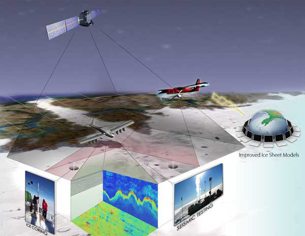
In the market for an autonomous airborne platform to scan ice sheets in the coldest, most isolated regions of the world with a powerful radar system, the engineers at the Center for Remote Sensing of Ice Sheets (CReSIS) couldn’t find an off-the-shelf solution. As Richard Hale explained it, there’s not an uncrewed autonomous vehicle (UAV) available commercially for the mission at hand — flying highly sensitive sensors a few hundred meters off the ground, in a tight grid, for hours at a time. “We had to develop a new UAV from scratch,” said Hale while talking from a cell phone on an airfield near the University of Kansas in Lawrence, where he was overseeing a flight test of different auto pilot systems. An associate professor in KU’s Department of Aerospace Engineering, Hale is leading the team developing the new aircraft, called Meridian. That day’s test involved smaller aircraft equipped with competing autopilot systems, to see which of two will play nicely with the rest of the UAV’s avionics and other instruments. The plane itself should be built and ready for testing by spring 2008. The Meridian will be capable of carrying about 55 kilograms of science equipment when it takes to the air. That’s far more than what such aircraft in the same price range can do, according to Prasad Gogineni, principal investigator for CReSIS, a National Science Foundation-funded Science and Technology Center. “The low end is not suitable to carry these radars that we want [to use] to measure the ice thickness, image the bed, map the layers simultaneously,” Gogineni said. “The UAV is going to allow us to do these things in a much more efficient fashion, with much finer resolution.” The Meridian offers the potential for more efficient operation than a crewed aircraft, like the Twin Otter, a small ski-equipped airplane used in the polar regions. The Meridian is specifically designed for the low-altitude, long-duration aerial sorties proposed by CReSIS, Hale said. He added that the Meridian will burn a tenth of the fuel as a Twin Otter while offering extended range and endurance. An aggressive schedule — coupled with what sounded like some bureaucratic, hair-pulling moments over securing test sites and procuring materials — has offered some challenges. The other chief challenge? “We’re designing the platform to carry the sensors at the same time that we’re developing the sensors,” Hale said. “One of the issues is that we didn’t know in advance what the payload was going to be.” The Meridian runs on autopilot during its flight missions, using pre-programmed, GPS-based waypoint navigation. An on-ground pilot will handle takeoffs and landings, much like a radio-controlled airplane. Gogineni said the integrated UAV might be tested in Greenland next summer, but will certainly be operational by the 2008-09 Antarctic summer. “We’ll be doing fine-scale measurements next year with the UAV,” he said. Back to main story: CReSIS to Mold New Models. |


For USAP Participants |
For The Public |
For Researchers and EducatorsContact UsU.S. National Science FoundationOffice of Polar Programs Geosciences Directorate 2415 Eisenhower Avenue, Suite W7100 Alexandria, VA 22314 Sign up for the NSF Office of Polar Programs newsletter and events. Feedback Form |


