On the reboundLARISSA data on post-glacial disappearance of ice key component to projectPosted September 18, 2009
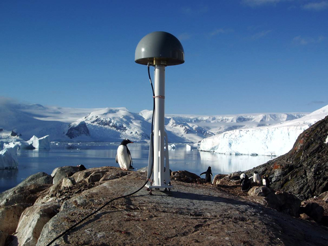
Eugene Domack The International Polar Year (IPY) The high-precision GPS stations, deployed from the ship over the course of three days, will help scientists determine just how much ice covered the peninsula about 20,000 years ago, when the northern and southern ice sheets had reached their farthest extent — called the Last Glacial Maximum (LGM). The GPS data can also provide details on more recent ice retreat. That information is important to help answer one of the key questions bugging scientists like Domack about the 2002 breakup of the Larsen B Ice Shelf, which had survived 10 consecutive millennia of fluctuating climates, perhaps some with average temperatures as high as today, before buckling in spectacular fashion. Scientists already know that smaller shelves to the north dissolved and reformed over the same time period. Has the region reached a climatic tipping point or has something else in the regional system that once protected the Larsen B from collapse in the past changed? Domack said the Bruce Plateau, which feeds ice to the Larsen Ice Shelf system, may have been the center of a large ice dome during the LGM. “The question is, ‘How thick was the ice?’ Are we simply seeing delayed recession of the Larsen B because the ice [was] so thick there that it’s taken thousands and thousands of years for the ice to have drained and gotten to the point where the shelf is thin enough to respond to a short-term warming? “The only way to test that idea is to look at crustal rebound over the long term as it reflects the load of ice many thousands of years ago,” Domack said. The GPS instruments not only detect the immediate elastic rebound of the bedrock as ice melts or calves from the ice sheet but also the long-term signal as the earth slowly heaves back into place thousands of years after the ice has disappeared. “We’re still seeing that rebound in Canada and northwestern Europe from the ice sheets that were in the northern hemisphere,” he explained. The GPS stations will actually do double duty for another major IPY project called POLENET (Polar Earth Observing Network) The installation of the stations near Ukraine’s Vernadsky Base, Hugo Island and Duthier’s Point near Palmer Station during the Gould expedition earlier this year went smoothly, according to Domack. Domack said three more such GPS stations will be set up on the eastern side of the peninsula during the main LARISSA cruise next year. Though the cruise got off to a rough start when reports of “ridiculously high seas” prevented the Gould from entering Drake Passage between the tip of South America and the Antarctic Peninsula for two days. It turned out to be a prudent decision, as the storm produced seas with waves in excess of 10 meters high. “I’ve been crossing the Drake since 1987 and I’ve never experienced a delay in crossing,” Domack said. While the installations went smoothly, they weren’t necessarily easy. Hugo Island, about 80 kilometers off the coast of the peninsula, is a difficult place to land a small boat even in the best of conditions. The GPS station at Duthier’s Point, a rocky knoll that offers access to higher elevations, required lugging nearly 700 kilograms of gear up a steep slope. Unfortunately, the transmitter on the GPS station on Hugo Island went down after the Gould left. One attempt to fix it didn’t work, and a subsequent attempt to access the small island failed. Domack said the ship would try again in September. “It’s an important one because it’s out on the shelf, away from the coast, and it gives us one of these good geographic points to see what the rebound is like from the ice out on the [continental] shelf,” he said. “The rebound data are critical in refining our ideas, constraining our hypotheses to a level we couldn’t do — that we haven’t been able to do — anywhere else in Antarctica until now.” NSF-funded research in this story: Eugene Domack, Hamilton College, Award No. 0732467 |


For USAP Participants |
For The Public |
For Researchers and EducatorsContact UsU.S. National Science FoundationOffice of Polar Programs Geosciences Directorate 2415 Eisenhower Avenue, Suite W7100 Alexandria, VA 22314 Sign up for the NSF Office of Polar Programs newsletter and events. Feedback Form |


