Ancient Ice LevelsScientists drill into Antarctic bedrock to see if the Icy Continent was once a bit less icyPosted April 20, 2017
Today, a massive sheet of ice covers nearly all of West Antarctica, but it likely hasn’t always been that way. 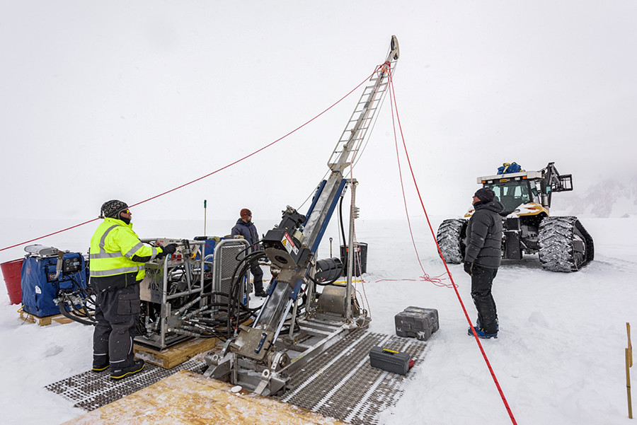
Photo Credit: John Stone
After positioning the drill platform, engines and hydraulic controls, IDDO drillers Mike Jayred (right) and Tanner Kuhl (center) look on as Clayton Armstrong raises the drill mast.
Over the past few hundred thousand years, researchers think that the ice sheets have waxed and waned, varying in size as the region’s climate changed. As they fluctuated, the ice sheets would have captured so much frozen water that sea levels around the world would have risen and dropped accordingly. The fate of the Antarctic ice sheets affects all parts of the planet. For scientists modelling future climate, the role the ice sheets play is one of the great unknowns, but it would certainly be significant. They estimate that if the entire West Antarctic Ice Sheet were to collapse, for example, it could raise global sea level by up to 15 feet on average. Counterintuitively, because of the interactions between the ice sheet and the Earth’s crust, the Northern Hemisphere would experience the biggest sea level rise from melting Antarctic ice. To gather hard geologic evidence of how dynamic the ice cover has been in the past, and may be in the future, John Stone of the University of Washington and his team traveled to a remote region of the continent this past season. “The aim of this project is to determine whether the ice sheet in West Antarctica has been thinner in the past,” Stone said. “Whether it has collapsed and contracted to a much smaller version of its present self.” 
Photo Credit: John Stone
Once the drill was erected, the team built a tent around it to shelter drilling operations from snow and winds.
They flew deep into the barren landscape to drill down and collect a bedrock sample buried under more than 100 meters of ice. By analyzing its atomic properties, they’re able to test to see whether there was a time when the ice sheets of West Antarctica were once just a shadow of what they are today. The research was supported by the National Science Foundation, which manages the U.S. Antarctic Program. “There’s a good deal of evidence from sea level change that ice sheets globally were smaller during the last interglacial 125,000 years ago,” Stone said. “So it’s widely presumed that West Antarctica participated in that deglaciation that led to higher sea levels.” The researchers needed to get at the underlying bedrock beneath the ice that covers most of the continent today. They’re looking for evidence that the rocks once laid out on the surface, free of ice and totally exposed to cosmic rays. While it’s common for glacial researchers to analyze rocks on the surface to see how long they’ve been exposed, taking rock cores from beneath the ice is new. “The cosmic radiation interacts with… and induces nuclear reactions inside the minerals of rocks, and changes atoms from one chemical isotope to another,” Stone said. “When rocks become exposed to cosmic rays they begin to build up quantities of isotopes like beryllium-10, aluminum-26, chlorine-36, helium-3 and neon-21, which are otherwise very rare isotopes.” Many of these atomic variants are radioisotopes that are unstable and break down into other stable isotopes through radioactive decay. These radioisotopes build up as long as the rocks are exposed, but when these rocks are buried underneath multiple feet of cosmic-ray blocking ice, the radioisotopes break down at predictable rates. 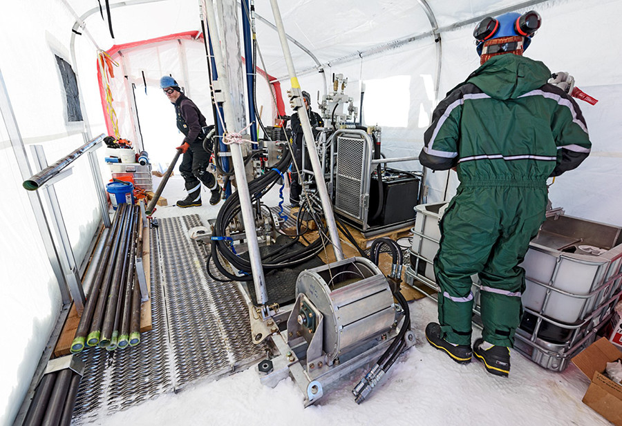
Photo Credit: John Stone
IDDO driller Mike Jayred (left) prepares to add a rod to the drill string while coring the pilot hole at the first site.
Different isotopes have different rates of decay, or “half-lives,” which range from a few microseconds, to billions of years. Stone and his team focused on isotopes that have half-lives in the thousands and millions of years. By looking at the ratios of these different isotopes, the researchers can discern when the last time this rock had been exposed, and from that, the history of the ice sheet over the last few hundred thousand years. “We will measure a whole family of isotopes which have different radioactive half-lives,” Stone said. “By comparing the concentrations of those isotopes, we’ll be able to tell whether the exposure was a long time in the past, or whether it happened fairly recently.” In order to get to the rock still covered in ice, the team worked with a drill designed by the U.S. Ice Drilling Program for subglacial bedrock drilling known as the Agile Sub-Ice Geologic drill, or the ASIG drill. It’s adapted from a commercially available drill used for mineral exploration, but with a number of modifications to make it better at drilling through ice rather than rock. The team originally hoped to take two cores during their field season. Unfortunately, just feet away from finishing their first hole, there was a problem and it had to be abandoned. “That was a big disappointment, especially because it was the first of the two holes,” Stone said. What exactly happened is still unclear, but after several days of troubleshooting, they made the decision to give up on their first attempt. Despite the setback, they focused on making sure their second attempt was successful. 
Photo Credit: John Stone
Geologists Perry Spector (foreground) and Trevor Hillebrand prepare to collect a rock sample from glacial deposits on Mt Tidd. In addition to the drill cores, scientists collected rock samples to study the history of the ice sheet above the current ice surface.
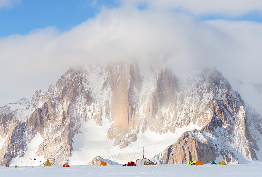
“We were able to get some auger bits flown out to us which simplified the business of getting a pilot hole drilled quickly, and with that done we were able to get a second hole started very efficiently,” Stone said. “The drill functioned exactly as it was meant to function for the second hole. It was really a very impressive performance actually.” Six days later, after cutting through 150 meters of ice, the researchers bored into the bedrock and extracted an eight-meter rock core. “These long profiles give you an idea of how far into rock cosmic rays penetrate,” Stone said. “Five or six feet, maybe a little further is the typical length of the profile where you’ll see the abundance of cosmic ray produced isotopes.” Picking the right spot was key for recovering the right kind of rock. The Pirrit Hills are an isolated collection of mountain peaks projecting out of the massive ice sheet in the middle of West Antarctica. “The Pirrit Hills are a beautiful place,” Stone said. “They’re actually quite substantial mountains, they’re called the Pirrit Hills but the three big peaks are sort of granite towers that are up to 800 or 900 meters above the ice sheet at that point.” These mountaintops, known as nunataks when only their peaks protrude out of the ice, are the ideal location in the region in part because they’re made of granite, the best material for isolating these radioisotope ratios. “Our knowledge of the subglacial geology and where different rock types are is not excellent over Antarctica,” said Perry Spector, also at the University of Washington. “So the fact that we’re right next to a mountain, a nunatak of granite, means that if we go just a little bit off board of there and drill down, we’re almost guaranteed to hit granite.” 
Photo Credit: John Stone
Clayton Armstrong lowers a core tube into the ASIG drill string prior to drilling the final section of bedrock core as drilling engineer Tanner Kuhl looks on.
The team had visited these peaks before. In 2013 and 2014 they traveled to the Pirrit Hills and two other nunataks in the region, to determine where would be best to drill, and to collect samples up the slopes of the exposed mountaintops. “We have samples that currently go from hundreds of meters above the ice, all the way down ridges in the Pirrit Hills, finally at the ice level we have several samples, and our drill core will be the next two samples down the profile,” Stone said. Collectively, these samples will give researchers a comprehensive picture of the ice sheet over thousands of years. “The ones below the ice sheet can tell us information about if and when the ice has been thinner there, but the ones above the modern ice level can tell you information about if and when the ice was thicker in the past,” Spector said. “You can get information about both times when the West Antarctic ice sheet was thicker and more extensive than it is now, as well as information about if and when it was thinner and less extensive.” The Pirrit Hills are also in a key location on the ice sheet itself, a spot that acts like a bellwether, which can reveal much about the West Antarctic Ice Sheet as a whole. “Part of the site selection was to find a place where ice thinning would be sensitive to a large scale change in the ice sheet,” Stone said. “Ice sheet model calculations suggest that you’d be looking at substantial deglaciation of West Antarctica in order to uncover that rock.” 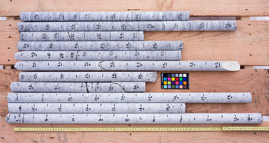
Photo Credit: John Stone
The scientists and drillers recovered 8 meters, or about 26 feet, of bedrock granite. Each section fit perfectly with the sections above and below it, ensuring a complete, uninterrupted record of cosmogonic isotopes.
The researchers are looking to the past to better understand what happens to the massive ice sheets in West Antarctica as climates warm in the modern day. “We think of it very much as a test of the sensitivity of ice sheets to climate change,” Stone said. “If we can establish which climates endanger the West Antarctic Ice Sheet then I think we can really make confident statements about future climates and the likely response of the Antarctic ice sheet to that. We sort of see it as looking at the vulnerability of the ice sheet to future climate change.” Understanding how the ice sheet behaved in past warm periods takes on extra importance as researchers are now trying to predict what might happen around the world as the current climate warms. As ice sheets melt, that water will flow into oceans and cause sea levels around the world to rise. Understanding how much the West Antarctic Ice Sheet is likely to melt will go a long way towards predicting how much extra water may end up in the oceans. Even though the West Antarctic Ice Sheet is on the far side of the planet, it would have a big impact in North America should it collapse. Counterintuitively, the Northern Hemisphere would experience the biggest sea level rise from melting Antarctic ice. “[The] deglaciation of Antarctica, rather than Greenland, actually has bigger effects in North America than the same amount of ice being released from Greenland,” Stone said. The huge weight of such a massive ice sheet actually deforms the Earth’s crust, flattening it out slightly. Should that ice melt and flow into the oceans, the planet’s surface would rebound and rise up, displacing that water towards the Northern Hemisphere. After spending about two months at the site, the team returned with the rock core that they’re now starting to process and analyze. “We’ve already started to cut sections from the core,” Stone said. They still need to carefully separate the pure mineral samples they want to analyze for the cosmic-ray produced isotopes within. “We’ve got measurements planned for four or possibly five cosmic ray produced isotopes in this rock,” Stone said. “They all have different half-lives, so by comparing them we will be able to get information about not only whether the rock was exposed but when.” NSF-funded research in this story: John Stone, University of Washington, Award No. 1341728 and Award No. 1142162. |

For USAP Participants |
For The Public |
For Researchers and EducatorsContact UsU.S. National Science FoundationOffice of Polar Programs Geosciences Directorate 2415 Eisenhower Avenue, Suite W7100 Alexandria, VA 22314 Sign up for the NSF Office of Polar Programs newsletter and events. Feedback Form |