Exploring BonneyENDURANCE robot dives into ice-covered lake to produce 3-D mapPosted May 22, 2009
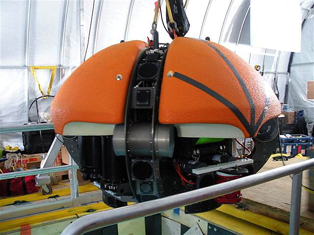
The robot that scientists deployed last year into ice-covered Lake Bonney The autonomous underwater vehicle (AUV), named ENDURANCE (Environmentally Non-Disturbing Under-ice Robotic ANtartic Explorer) Robots in Antarctica
ENDURANCE is just one of a growing number of robots that scientists are using to explore places above and below the ice-covered continent. See the article Robots in Antarctica for more on this subject.
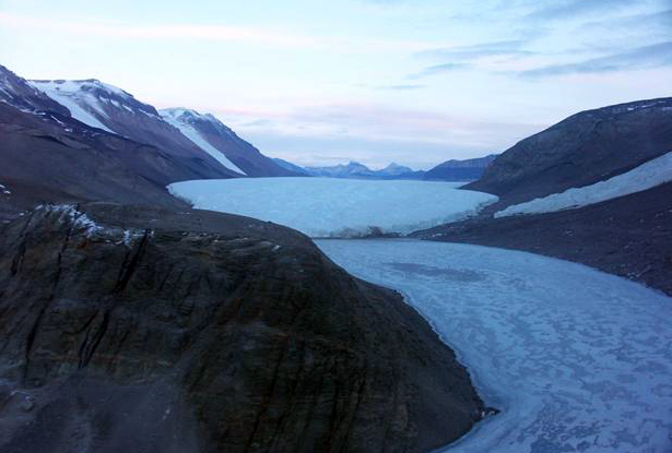
It came as something of a surprise, then, that microbubbles of gas were able to push ENDURANCE around a bit while it explored the cold depths of the briny lake. “We knew these lakes were supersaturated with gases, and yet a bunch of very smart people did not predict that these gases meant microbubbles would form on every surface of the vehicle and cause buoyancy problems,” mused Peter Doran ENDURANCE made its first underwater foray into Lake Bonney last field season. Its job is to create three-dimensional maps of the underwater environment, which includes the face of Taylor Glacier. It also carries a suite of instruments that allow it to measure water characteristics like salinity and acidity, and probe for evidence of microbial life. Doran and his collaborators on the NASA-funded Doran said the team was able to overcome the buoyancy problems, but the experience proved the utility of such field tests in the challenging Antarctic environment, which researchers often use as an analogue for outer space scenarios. “To me this was a real lesson for doing autonomous science on say Europa,” explained Doran, a professor of earth and environmental sciences at the University of Illinois at Chicago “And that’s in an environment [Lake Bonney] we already know a lot about,” he added. “Imagine now going into a completely unknown environment on another planetary body. You really need precursor preliminary data, and even without that, there are risks to going there for sure.” Lake Bonney, a saline lake about 3 kilometers long and 1 ½ kilometers wide, is one of a series of lakes in the relatively ice-free McMurdo Dry Valleys. The area is part of the McMurdo Long Term Ecological Research (LTER) 
Photo Credit: John Priscu/Antarctic Photo Library
The west lobe of Lake Bonney, foreground, and the Taylor Glacier.
Scientists believe that Bonney and the other lakes in the valleys are the remnants of much largerbodies of water that once dominated the area. A thick, salty, nutrient-rich layer of water in Bonney, where most of the lake’s photosynthetic microorganisms live, is leftover carbon material from the retreat of those great lakes many millennia ago that the little critters subsist on. Recent research published in the journal Science suggests that some microbial communities have evolved even more unique survival capabilities. Another group of scientists collected samples of water, originating from the base of the Taylor Glacier, that contained microorganisms but no oxygen. They believe that, lacking enough light to make food through photosynthesis, the microbes have adapted over the past 1.5 million years to manipulate sulfur and iron compounds to survive. [See related story: Ancient microbes.] ENDURANCE promises to expand further what the researchers are learning about life on the extreme. “ENDURANCE blew us away. In the end, it did everything we asked of it,” said Doran, whose particular interest is in the Dry Valleys lakes and their history. Though engineers designed ENDURANCE to work without input from them, swimming on its own based on a set of pre-programmed instructions and autonomous functions, the scientists employed a fiber optic leash, or tether, for this experimental phase of the project. “Without the fiber [leash] we would have no way of knowing whether it is making the right decisions until – and if – it came back,” Doran noted. “With the fiber we can watch over its shoulder and step in if we need to override or something. “It’s complete peace of mind — and keeps us from getting bored,” he added. “Also, we have found that it increases our productivity since we have often changed the mission in the middle to acquire more data based on some discovery.” However, in the case of an emergency, such as if the cable snapped or the team at the surface had to cut it because of a snag, ENDURANCE is programmed to return to base camp — a hole cut into the lake surface sheltered by a specially built boat house. “The vehicle’s coming-home ability is amazing to me,” Doran said. “No matter how far out it is, or how long it has been out there, it finds its way back to the hole just by knowing where it’s been,” he explained. “It has an incredibly accurate bottom tracker and laser-ring gyro for orientation. At the end of the mission, it just unravels its path out, calculates a trip home, and does it to sub-meter accuracy. When [it] gets under the hole, it tracks a light beam to the surface without touching the hole walls.” Doran and his team will return this coming field season to complete three-dimensional mapping of the lake and to create a photo mosaic of the glacier face. Various delays last year caused a late field deployment, and then warm weather caused the streams to flow, mucking up visibility in Bonney for the photo imaging. “But we did accomplish much of the 3-D mapping, and will complete this in the coming field season,” he said. “We also did do mapping of the glacier face and will finish the underwater imaging this season as well. “We are hoping for some really good data this year.” NSF-funded research in this story: NSF-funded research in this story: Peter Doran, University of Illinois at Chicago, Award No. 0096250
|


For USAP Participants |
For The Public |
For Researchers and EducatorsContact UsU.S. National Science FoundationOffice of Polar Programs Geosciences Directorate 2415 Eisenhower Avenue, Suite W7100 Alexandria, VA 22314 Sign up for the NSF Office of Polar Programs newsletter and events. Feedback Form |


