|
Mystery solvedMountain formation under Antarctic ice sheet began a billion years agoPosted November 25, 2011
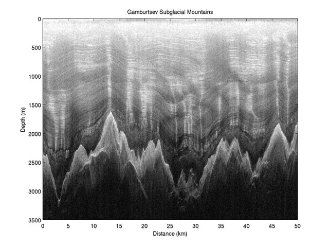
Scientists have described how a mountain range the size of the European Alps — but buried under Antarctica’s giant ice sheet — came into existence through a process that began a billion years ago. The research was published in the science journal Nature last week. In 2009, an international team of researchers explored the subglacial Gamburtsev Mountains in East Antarctica by using two twin-engine aircraft equipped with ice penetrating radars, gravity meters and magnetometers. First discovered in 1958, the mountains are buried beneath as much as three kilometers of ice. [See previous article — Mountainous Mystery: An international research team will head to the high plateau in East Antarctica to probe subglacial feature.] The project was one of the flagship programs of the International Polar Year 
Photo Credit: BAS
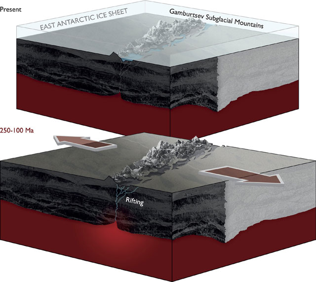
Schematic shows that proposed rifting processes within the East Antarctic Rift System provided the tectonic trigger for uplift of the Gamburtsev Mountains.
Dubbed AGAP, for Antarctica’s Gamburtsev Province The Nature paper describes how the mountains were originally formed after several “micro-continents” collided, crushing the oldest rocks of the mountain range together. This plate tectonic version of demolition derby formed a thick crustal root, which extended beneath the mountain range. Over time, the ancient mountains eroded but the cold dense root was left behind. Then, around 250 to 100 million years ago, rifting paved the way for the supercontinent Gondwana to break apart, which included Antarctica, causing the old crustal root to warm. This rejuvenated crustal root, together with the East Antarctic Rift, a 3,000-kilometer-long fracture in the Earth’s surface that extends from East Antarctica across the ocean to India, forced the land upwards, reforming the mountains. Rivers and glaciers carved deep valleys, which helped uplift the peaks to create the spectacular landscape of the Gamburtsevs. “Understanding the origin of the Gamburtsevs was a primary goal of our International Polar Year expedition,” said lead author Fausto Ferraccioli with BAS in a press release. “It was fascinating to find that the East Antarctic rift system resembles one of the geological wonders of the world — the East African rift system — and that it provides the missing piece of the puzzle that helps explain the Gamburtsev Subglacial Mountains. “The rift system was also found to contain the largest subglacial lakes in Antarctica,” he added. The East Antarctic Ice Sheet, which scientists believe formed about 34 million years ago, protected the mountains from erosion. That ice is also shielding the mountains from direct sampling by researchers eager to learn more about Antarctica’s hidden mountain range. “The next steps will be to assemble a team to drill through the ice into the mountains to obtain the first rock samples from the Gamburtsevs. Amazingly, we have samples of the moon but none of the Gamburtsevs,” said co-author Robin Bell of Columbia University’s Lamont-Doherty Earth Observatory “With these rock samples we will be able to constrain when this ancient piece of crust was rejuvenated and grew to a magnificent mountain range,” she said. Alexandra Isern, program director for Antarctic Earth Sciences “The scientific explorers of the AGAP project worked in harsh conditions to collect the data and detailed images of this major mountain range under the East Antarctic Ice Sheet,” she said. “The results of their work will guide research in this region for many years to come.” NSF-funded research in this story: Robin Bell and Michael Studinger, Lamont-Doherty Earth Observatory of Columbia University, Award No. 0632292
|


For USAP Participants |
For The Public |
For Researchers and EducatorsContact UsU.S. National Science FoundationOffice of Polar Programs Geosciences Directorate 2415 Eisenhower Avenue, Suite W7100 Alexandria, VA 22314 Sign up for the NSF Office of Polar Programs newsletter and events. Feedback Form |


