|
Produced by Lauren Lipuma for the U.S. Antarctic Program | Read a transcript of this video
Radar satellites spot dangerous crevasses humans can’t seeResearchers are using the technology to plan traverse routes through rift-laden territoryPosted July 12, 2021
Antarctic researchers and support staff can now more easily find and avoid dangerous crevasses on long traverses carrying supplies to remote camps and stations, thanks to the help of a German radar satellite. An international team of scientists and engineers recently found that radar satellites can reliably detect crevasses in Antarctic ice even when they are hidden beneath feet of snow. They are now using the satellite data to map locations of crevasses along routes used for traverses, where fleets of tractors drive fuel and supplies over the ice for hundreds of miles to remote field camps and other parts of Antarctica. The new tool helps make long, overland supply drives safer and faster, while also providing glaciologists with a new way to study the movements of ice sheets from afar, according to the authors of a recent study describing how to use the method. “For me it was really satisfying to see that it can actually work, if you have high-enough resolution,” said Zoe Courville, an engineer at the U.S. Army’s Cold Regions Research and Engineering Laboratory in Hanover, New Hampshire and co-author of the study. “It was a huge advantage.” Spotting fissures in the iceThe U.S. Antarctic Program South Pole Traverse covers more than 1,000 miles each austral summer to transport fuel and supplies from McMurdo Station to Amundsen-Scott South Pole Station. Multiple convoys of tractors haul hundreds of thousands of gallons of fuel across the Ross Ice Shelf and through the Transantarctic Mountains to the Polar Plateau. Part of the journey takes the tractor operators through the McMurdo Shear Zone, an area of the Ross Ice Shelf laden with rifts and crevasses. 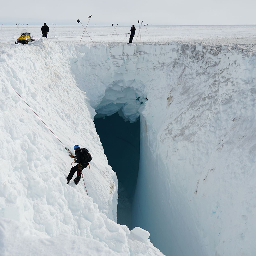
Photo Credit: Zoe Courville
Members of the U.S. Antarctic Program’s South Pole Traverse team rappel down into a crevasse to get a better view.
Just a three-mile section of the Shear Zone has dozens of crevasses the drivers must navigate around. The problem is crevasses are hard to spot – they’re often buried by several feet of snow. Planes and satellites typically can’t see them and neither can human eyes on the ground. “You look out, and it's just this flat, seemingly safe surface,” Courville said. But radar beams, unlike visible light, can penetrate into snow. Traverse drivers typically sniff out cracks in the ice with a ground-penetrating radar (GPR) instrument attached to a 20-foot pole mounted to the lead tractor. The GPR reliably detects voids and cavities in the ice, but it only gives the convoy four seconds of warning if it spies a crevasse. Now, Courville and the traverse teams are using high-resolution radar images from the German TerraSAR-X satellite to get a birds-eye view of where the rifts are before even setting foot on the ice. Courville and her colleagues tried to use radar satellite imagery to detect crevasses in the past, but the resolution wasn’t reliably high enough to see individual cracks in the ice. On an unrelated project, Oli Marsh and Dan Price, glaciologists with the British Antarctic Survey and University of Canterbury/Antarctica New Zealand, were using high-resolution imagery from TerraSAR-X to study other areas in the Antarctic. They discovered that when the satellite was used in spotlight mode – where it focuses its radar beam on one small area for a longer period of time – the resolution was high enough to pick up individual crevasses. Finding a way through the mazeIn 2017, Price and Marsh teamed up with Courville, who supports the U.S. Antarctic Program to execute the South Pole Traverse each year, to see if they could use the TerraSAR-X data to better navigate through dangerous crevasse fields. Price had been tasked with planning a new traverse route for Antarctica New Zealand across the Ross Ice Shelf to a field camp on the Siple Coast, where scientists are studying the dynamics of the West Antarctic Ice Sheet. The area is so foggy it’s difficult to bring in supplies by plane, so an overland traverse is a better option, Price said. 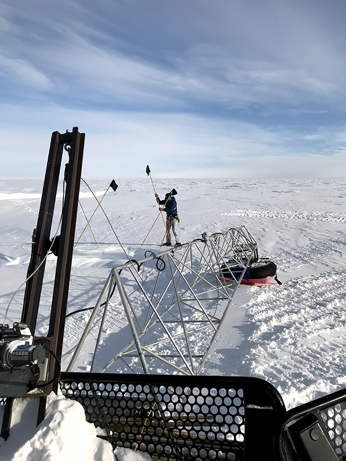
Photo Credit: Zoe Courville
Members of the South Pole Traverse team mark the location of a crevasse with flags.
“We had to get across an area of Antarctica that hadn't been crossed before, and had to plan a route ahead of time,” he said. “This TerraSAR-X imagery really gave us an advantage with that.” Using just the ground-penetrating radar instruments on traverse vehicles is like trying to find a way through a maze, Price said. But the TerraSAR-X imagery essentially gives them a map of the maze from above. “If you get stuck in a certain area, you can use this to try to navigate around it,” Courville said. “You're not just driving out there blind, like in the past.” Once they have the map in hand, the researchers plan a preliminary traverse route but they still need to verify the data by traveling the route on the ground and making sure the crevasses are where the satellite says they are going to be. It’s not always easy – the ice is constantly flowing toward the ocean, taking the crevasses along with it. Using maps made weeks or even months in advance means the rifts may not be in the exact spot the satellite marks. But the researchers found the satellite data was reliable and even helped the U.S. team find a shortcut in their route from McMurdo to the South Pole in November 2019. The satellite images showed them a path they could take as they reset their course through the McMurdo Shear Zone that avoided two large crevasses and allowed them to turn toward the Pole sooner than expected. “It's basically a shortcut now, and everyone likes that early turn toward the south,” Courville said. Studying ice from spaceThe new radar imagery is useful beyond planning traverse routes: it can also help researchers study how ice sheets and glaciers behave, especially in a warming climate, Price said. Crevasses tend to form where one stretch of ice moves much faster than the area next to it. “Where crevasses are happening is interesting for trying to work out how the ice is flowing,” he said. “So [this gives us] a better understanding of how the ice is moving off the continent, and how the ice is interacting with itself.” The new imagery can also help glaciologists working on the opposite side of the globe, according to Courville. “Greenland is going through very rapid changes in the glaciers that we're studying there,” she said. “So I think there's a lot of really interesting science work that can be done by being able to track changes at such high resolution.” “It's an incredible piece of the puzzle,” Price said. “And moving forward it's an incredible safety tool.” This work was supported by the National Science Foundation, which manages the U.S. Antarctic Program. Video imagery provided by:
Video music: Black Snow by Airtone |
"News about the USAP, the Ice, and the People"

For USAP Participants |
For The Public |
For Researchers and EducatorsContact UsU.S. National Science FoundationOffice of Polar Programs Geosciences Directorate 2415 Eisenhower Avenue, Suite W7100 Alexandria, VA 22314 Sign up for the NSF Office of Polar Programs newsletter and events. Feedback Form |
