Page 2/3 - Posted September 18, 2009
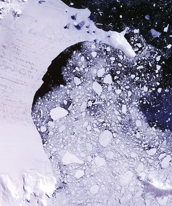
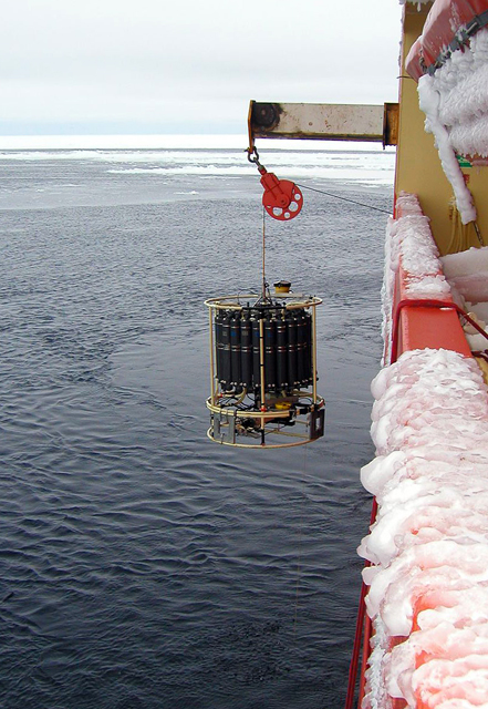
Fingerprints in the mudThe Larsen B collapse was unusual because the ice melted from the top down after an unseasonably warm 2002. That’s different from what’s happening on the other side of West Antarctica, where warm seawater is melting glaciers from the bottom up. “There are a lot of things that may have contributed to the ice shelf breakup, which seems to be an unprecedented event in the last 10,000 years,” explained Domack. “We’re not sure whether this is a climate tipping point or not — a permanent passing of the region from one climate state to another. The sedimentology record is vital in determining that.” The scientists can learn much about the region by drilling various cores into the seafloor sediment that accumulated before and after the Larsen B disappeared — a job made much easier now that the ice shelf is gone. One goal will be to determine if there is a signature — a sort of sedimentological fingerprint — of ice shelf collapse in the mud and sand. “[If] so, we can recognize similar events in other parts of the Antarctic or the world,” Domack said. “Some of [the sediment record] might represent subglacial lake deposits, and some of it might represent a rather catastrophic flush of sediments as the ice flow from the land accelerated following the ice shelf demise in the first few months,” he added. The subglacial lake, in particular, is intriguing. Did it play a role in the demise of Larsen B, perhaps destabilizing the grounding line where ice met bedrock? “We’ll have access to this subglacial lake [sediments] with the ship now that the ice is gone, so we can sample it in detail that you probably couldn’t do by drilling through ice,” Domack said. “No matter how many holes you punch through [an ice shelf], you can’t get the kind of detail that we’re going to have access to.” New opportunitiesThanks to the LARISSA project, Bruce Huber In addition to standard CTD measurements — profiles of ocean conductivity (to determine salinity), temperature and depth (measured as pressure) taken by a profiler deployed from the vessel — the oceanographers hope to set out as many as eight moorings with a suite of instruments. Anchored to the seafloor by weights and well below the reach of passing icebergs, the instruments will measure things like salinity, temperature, and current speed and direction over two years before the Palmer retrieves them in 2012. Huber said the moorings will also trap organic material as they fall through the water column for later study. “The sediment traps are of interest to all the components of this program because the sediment rain will consist of particulates brought into Larsen B area by melting shelf ice,” he explained. “It will also include remains of biological organisms — phytoplankton, zooplankton — that grow and die in the water column and sink when they’re finished. “By looking at a time series of this accumulation we can get a better idea of the processes ongoing in this area,” he added. Maria Vernet “It is a very special community, organized to take advantage of gases that come off the crust,” she explained. “We want to characterize that community, so we want to find a live one that is still functional.” Vernet’s particular specialty revolves around phytoplankton — free-floating, unicellular algae that bloom in the upper reaches of the ocean in an area scientists call the photic zone where light is available and photosynthesis occurs. The recent introduction of this new source of organic carbon is expected to change the dynamics of the benthic, or seafloor, community of animals, according to Vernet. “The communities would now look more similar to the western side of the peninsula,” she explained. Other members of the ecosystem team will look more closely at the seep community, if one can be found, studying the relationship between the chemical-loving bacteria and the larger animals that likely have bacteria living in them so they can turn the chemical carbon into energy. “It’s a very particular, symbiotic relationship between bacteria and animals,” Vernet said. Work from the Palmer for this part of the cruise will include samples using the CTD profiler and capturing animals using nets. Sediment traps will also be a key experiment to determine how much and what kind of organic carbon sinks to the floor — and where — to feed the benthic animals. “So, for example, if there are more phytoplankton close to the coast, then they’re going to be able to maintain a higher density of benthic animals,” Vernet said.Back 1 2 3 Next |


For USAP Participants |
For The Public |
For Researchers and EducatorsContact UsU.S. National Science FoundationOffice of Polar Programs Geosciences Directorate 2415 Eisenhower Avenue, Suite W7100 Alexandria, VA 22314 Sign up for the NSF Office of Polar Programs newsletter and events. Feedback Form |


