|
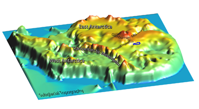
Geophysical air campaign will fly 20 hours a day for one monthThe heavily supported geophysical air campaign will begin next season in 2008. The current plan is to fly two Twin Otter aircraft for nearly 20 hours per day out of one or two field camps located near Dome A. The U.S. Antarctic Program (USAP) “This would give us more flexibility in designing the survey and covering a larger area over the Gamburtsev Subglacial Mountains,” Studinger said. Earlier this year, GAMBIT scientists tested the concept with a Twin Otter carrying two new gravimeters on a flight from Ellesmere Island, Canada, to the North Pole and back. “The test flights went very well,” Studinger said. “Next year we plan to install the complete system consisting of radar, laser, gravimeter and magnetometer systems for the first time.” Tests will follow in Calgary and Greenland. If all goes well, the scientists will install the same system at McMurdo Station before heading into the field. “We will probably fly about four weeks, 20 hours a day, assuming the weather is fine,” Studinger said. With the Americans and British covering the air and the ground, the Chinese will head down into the ice and rock itself. “The Chinese want to select an ideal drill site for ice-core drilling,” Studinger explained. “This is something they plan to do in subsequent years. This ice core drilling will also recover a bedrock sample in a handful of years.” The hypothesesHypotheses for the mountain range’s origin are fairly sketchy at this point due to the lack of data. One theory says the mountains are hot-spot volcanoes that came up through the crust. “We don’t think so, but that’s one hypothesis on the table,” Bell said. Another idea is that the mountains represent an area of high topography, protected from erosion by a layer of relatively tough, weather-resistant rocks. “What’s really surprising is that the mountains are there,” Studinger noted, explaining that the Gamburtsevs appear circular, an interior continental feature difficult to explain by plate tectonics. Wiens said most researchers believe the mountains are much older than what the “hot spot” theory would allow — an age of tens of millions of years, versus hundreds of millions of years. Rocks found at the coast are at least 500 million years old, he said. “By extrapolation, then, people think that probably the rocks in the middle of the continent are very old,” he explained. “But nobody really knows.” Each measurement will give the scientists different clues as they puzzle out the origins of the subglacial range and its larger role in the continent’s history. Ice-penetrating radar, for example, will give them details on ice thickness and layering above the Gamburtsevs. Other instruments will provide details on the gravity field, which indicates the type of rocks that are present. “We have to compare these data to other existing features on the Earth, which we can, and usually we can exclude some models or some ideas and narrow it down to one or two in the end,” Studinger said. AGAP will make use of brand new tools in the venture, according to Wagner. Seismometers with ultra-cold rated motors were developed just for this project. The ice-penetrating radar is the latest design from the Center for the Remote Sensing of Ice Sheets More mysteryThe region where the subglacial mountain range sits holds other prizes for science. “One of the science-drivers behind the survey is not only the geologic origin of the Gamburstev Subglacial Mountains, but also the science community is very convinced that this region in Antarctica … is where people hope to find the oldest ice,” Studinger explained. “It would be one of the really important outcomes to locate the region with the oldest ice,” he added. The educated guess is that the ice is at least 1.5 million years old. A low snow accumulation rate combined with a slow-moving ice sheet gives scientists reason to believe this. The researchers also think the Gamburstevs were the nucleation point for the East Antarctic ice sheet, which formed more than 30 million years ago. Adding to the mystery: “We don’t even know if the mountains were there 35 million years ago,” Studinger said. Said NSF’s Wagner, “Because of their height and location, the Gamburtsevs are where the ice sheets start according to our best models. That’s why understanding when they formed — before or after the ice sheets — and characterizing their topography is so important.” “If you want to put East Antarctica into the global plate tectonic framework, you have to understand the tectonic evolution through time in this region,” Studinger added. NSF-funded research in this story: Robin Bell and Michael Studinger, Lamont-Doherty Earth Observatory of Columbia University; and Doug Wiens, Washington University in St. Louis.
|


For USAP Participants |
For The Public |
For Researchers and EducatorsContact UsU.S. National Science FoundationOffice of Polar Programs Geosciences Directorate 2415 Eisenhower Avenue, Suite W7100 Alexandria, VA 22314 Sign up for the NSF Office of Polar Programs newsletter and events. Feedback Form |


