|
Science - Recent Headlines Most Recent
Quick Find
More ResultsJan
30
2023
Ghost particles give scientists first look inside an active galaxyScience | Space and Atmospheric Physics The IceCube Neutrino Observatory has detected about 80 high-energy neutrinos emitted by a single active galaxy over the course of ten years. Jan
17
2023
How juvenile Antarctic krill survive when it's cold, dark and icyScience | The Biological World A pair of recently-published companion studies help clarify how juvenile Antarctic krill survive the long winter season. Jan
09
2023
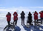
South Pole winter crew participate in virtual reality studyScience | Space and Atmospheric Physics Station staff tested a therapy that could be used on future space missions Dec
19
2022
Hunt begins for Antarctica's oldest iceU.S. researchers on the southernmost continent are in the midst of their first field season of a multi-year project to find and extract the oldest ice in Antarctica. Nov
21
2022
Weddell seal moms sacrifice diving capacity to help pups growScience | The Biological World Nursing Weddell seal moms transfer so much iron to their pups through their milk that they can't spend as much time underwater in the months after their pups are weaned, according to new research. Nov
07
2022
Female leopard seals are way, way bigger than their male counterpartsScience | The Biological World New research shows female leopard seals can be up to twice as large as males, a far bigger difference in body size between the two sexes than biologists previously observed. Oct
24
2022
Rumbles, booms and growls: Listen to the first recordings of these Antarctic whale callsScience | The Biological World Biologists are getting their first real listen to the vocalizations made by Antarctic minke whales, the most abundant yet least understood whale species in the Southern Ocean. Oct
04
2022
Follow the magma: Scientists map plumbing beneath Mt. Erebus for the first timeA 20-kilometer-wide tube of melted rock feeds the lava lake at Mt. Erebus, according to new research that illustrates the plumbing below Earth's southernmost active volcano for the first time. Aug
29
2022
Genetics reveals how fish and seals adapt to Antarctic coldScience | The Biological World New research into seal and fish genomes is giving scientists clues to how these hardy animals evolved to survive the extreme cold of Antarctica and the Southern Ocean. Aug
22
2022
Key Antarctic fish species declining due to climate changeScience | The Biological World New research finds populations of Antarctic silverfish along the West Antarctic Peninsula are plummeting due to warming temperatures and the loss of sea ice caused by climate change. Jun
06
2022
Shedding fluffy baby fur shapes how Weddell seal pups learn to swimScience | The Biological World Molting status determines when Weddell seal pups are ready for life in the water more than other developmental milestones, according to new research. May
02
2022
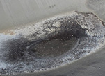
Wintertime flow of Blood Falls caught on camera for the first timeResearchers have caught a wintertime release of brine from Blood Falls on camera for the first time, but the exact cause of the curious phenomenon remains a mystery. Apr
18
2022
Antarctic microbe produces potential cancer-fighting drugScience | The Biological World Researchers map the genetic machinery behind a natural anti-cancer compound from Antarctica for the first time
|
||||||||||||||||||||||||||||||

For USAP Participants |
For The Public |
For Researchers and EducatorsContact UsU.S. National Science FoundationOffice of Polar Programs Geosciences Directorate 2415 Eisenhower Avenue, Suite W7100 Alexandria, VA 22314 Sign up for the NSF Office of Polar Programs newsletter and events. Feedback Form |