|
Pine Island cruiseScientists deploy robotic sub, moorings to study fast-moving glacierPosted April 17, 2009
Stan Jacobs The glacier, fronted by a small floating ice shelf, is one of the fastest moving rivers of ice on the continent, and one of the main sources contributing to sea-level rise out of West Antarctica. But the heat from below, not above, is thinning the ice shelf and allowing the glacier to flow more quickly into the ocean, according to researchers like Jacobs. During that first trip in 1994, when scientists knew “next to nothing” about the ocean circulation and seafloor topography of the bay where the glacier empties, they noticed a mass of “warm” Circumpolar Deep Water (CDW) on the continental shelf. A few degrees Celsius higher than the frigid surface conditions, this water intrudes on the shelf at depths of about 300 meters or more, running through glacier-carved troughs that allow it access to the ice above. “We’re fairly sure that the process we happened upon was ongoing at the time we arrived, but we don’t have any easy way to determine what the ocean conditions were on the shelf prior to 1994 because there were no measurements then,” said Jacobs, a research scientist at Lamont-Doherty Earth Observatory at Columbia University All of their visits have occurred during the austral summer, when sea ice is at its minimum, to allow the research vessel easier access to Pine Island and other ice shelves in the region. The researchers have compiled a good time series of data around that particular time of the year. “What we don’t really know is how the deep water varies year-round and from year to year,” Jacobs said. The scientists hope to fill the gap after this latest expedition, he added. “The main thing we were trying to do this time was set out a series of moorings that could record the winter properties and the currents over a couple of years. We can then gain a better understanding of how the deep water forcing changes over time.”
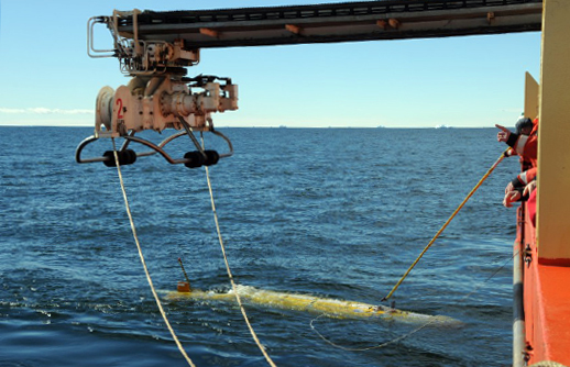
Part of the International Polar Year (IPY) “On the six missions beneath the ice, the sub performed exactly as it was programmed; the only problems were caused by the unknown nature of the environment into which we were sending it,” Jenkins reported via e-mail in March following the expedition. The sub — part of a £5.86 million British program to explore the marine environment beneath floating ice shelves — is 7 meters long, powered by 5,000 D-cell batteries, and can range up to 400 kilometers and to depths of 1,600 meters. The sub’s main job was to explore the underside of the ice shelf and the deep channels in the seafloor that can funnel the warm water to the ice. The yellow-colored submarine penetrated nearly 60 kilometers to the vicinity of the grounding line, where ice meets seafloor, after making three forays of about half that length. It was near the start of the return leg of the fourth trip when the sub collided with the ice base, according to Jenkins. “We believe it ascended into a basal crevasse,” he explained. “We cannot be sure of the exact dimensions, but it had to dive over 100 [meters] down to find an escape route. It then travelled 55 [kilometers] back to the rendezvous with the ship, despite having sustained damage to the nose.” The sub covered about 510 kilometers, spending 94 hours beneath the ice shelf. This was only the second time such a machine has ventured into this little-explored realm. The previous adventure was a 50-kilometer run beneath Antarctica’s Fimbul Ice Shelf The robot apparently proved its worth, yielding “a wealth of data on the [ice shelf] cavity shape and its seawater properties. … [It has] substantially altered our thinking about ocean circulation under the [Pine Island Glacier],” Jenkins wrote in one of the weekly ship’s logs. “Unexpected features in the cavity morphology have major implications for basal melting and glacier advance,” he added. While still crunching the data, Jenkins said the sub tracked the depth of the ice shelf base and seabed, and the temperature and salinity of the seawater. “This will enable us to determine the route by which ocean currents transport heat to the ice shelf base to fuel the high melt rates.” |


For USAP Participants |
For The Public |
For Researchers and EducatorsContact UsU.S. National Science FoundationOffice of Polar Programs Geosciences Directorate 2415 Eisenhower Avenue, Suite W7100 Alexandria, VA 22314 Sign up for the NSF Office of Polar Programs newsletter and events. Feedback Form |


