|
ANDRILL returns to Antarctica$30 million project seeks to understand continent's geologic past to predict how future climate change will affect ice sheets and sea levelPosted November 1, 2007
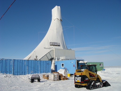
Thirty meters down. “Only 970 meters to go.” That was David Harwood’s matter-of-fact statement on Wednesday, Oct. 17, from McMurdo Station, a day after the ANtarctic geological DRILLing program (ANDRILL) extracted its first sediment core from under the sea ice in McMurdo Sound. “We’re very pleased with the progress to date,” said Harwood, ANDRILL principal investigator and this season’s co-chief scientist running the research operation out of McMurdo Station. The program is an international collaboration between the United States, New Zealand, Italy and Germany. One of the premiere projects of the International Polar Year (IPY), ANDRILL is a $30 million geological time machine. Using a specialized rig adapted for drilling in the Antarctic, drillers from New Zealand and Australia will bore deep into the marine basin to extract a kilometer-long sediment core about the width of a human fist. Glacial rocks, sand, volcanic ash, siltstone and mudstone are some of the elements that comprise the ANDRILL core – just a thick mass of interestingly colored and varied mud to the untrained eye. More Information But scientists can read the pebbles, hues, cracks and fossilized critters within – like literary scholars poring over an old, yellowed manuscript – and determine what the continent’s coastline and ice sheets were doing millions of years ago as the climate heated up and cooled off. That information is important to understand how Antarctica and its ice mass will respond to climate change in the next century when temperatures and carbon dioxide levels rise to levels similar to those millions of years in the past. Harwood, a professor of geosciences at the University of Nebraska-Lincoln, refers to the ANDRILL mission as “drilling back to the future.” Tom Wagner is the program manager for the National Science Foundation’s Antarctic Earth Sciences Division, which provides the U.S. funding for the international project. He explained that unlocking Antarctica’s geologic past is the key to understanding the future in terms of climate. “That’s why ANDRILL is so important: It’s drilling back to this time that really tells us where we’re going,” he said.
It’s not just about treading waterRising sea level isn’t the project’s only preoccupation in studying Antarctica’s role in global climate change.The sea ice that surrounds Antarctica, nearly doubling the size of the continent during winter, is a crucial factor in driving Earth’s climate. When sea ice forms, it pushes the salt out, creating a mass of cold, salty, dense water that sinks to the bottom of the ocean, creating deep ocean currents that affect ocean circulation and the distribution of heat worldwide. Upset the balance of sea ice – as global warming threatens to do – and you disrupt the Earth’s conveyer belt for circulating heat. Wagner explained that the Antarctic ice sheets also play a crucial role in how scientists determine what climate was like in the past by comparing ratios of oxygen atoms – oxygen-16 and oxygen-18 – to understand the past temperature of the ocean. “The amount of ice in Antarctica sets that ratio everywhere else in the world,” he said. Oxygen-16 occurs in higher concentrations in snow and ice. That’s because O-16 evaporates more easily from the ocean, and then falls as precipitation in Antarctica. This, in turn, enriches the O-18 in the ocean. Deep-sea sediments contain the shells of small organisms called foraminifers. When foraminifers are alive, they fix within themselves a ratio of these two types of oxygen atoms in the lattice of the calcite that form their shells, according to Steve Pekar, an ANDRILL researcher who works as a professor at Queens College and as a scientist at Lamont Doherty Earth Observatory of Columbia University. By analyzing oxygen isotope ratios in foraminifers, scientists have been able to determine when the Earth has produced more glaciers, and hence determined the times when ice ages have occurred. However, the story is a bit more complicated than that, Pekar said. “The conundrum with using oxygen isotopes to determine climate is that its values are controlled by multiple variables, of which ice volume and the temperature that the calcite was precipitated in are the most important.” Fluctuations in climate or changes in the strength and extent of deep-sea water masses like currents can affect bottom water temperatures, he explained. The latter can be due to opening and closing of oceanic gateways and other non-climatic events. “This has led to problems in deciphering climate using oxygen isotopic records and other climate proxies,” Pekar said. (Read about how scientists have found a way around this problem at the ANDRILL Isotopes page.) So while oxygen isotopes have provided a good overall view of what climate and ice volume has done over the last 65 million years, changes in water temperature can skew our interpretations of what is really happening in Antarctica, according to Pekar. Hence, the need for ANDRILL’s sediment records.
First seasonLast year in its first operational season, ANDRILL pulled out an Antarctic-record 1,285 meters of rock core, representing geologic time to about 13 million years ago. One key target was to look at a period of around 3 to 5 million years ago in the Pliocene, which scientists know to be warmer..jpg', 'sunImages', 450, 299, 'yes');)
Photo Credit: Peter Rejcek
Splitting core last year during ANDRILL's first field season. The operation took place on the McMurdo Ice Shelf, about 12 kilometers from the American and New Zealand research stations on Ross Island. New technologies allowed ANDRILL to punch through 85 meters of shelf ice and down another 840 meters of seawater to the seafloor. The team boasted a sediment core recovery rate of 98 percent, considered phenomenal for such an operation. The results were even more startling. The team’s sedimentologists, who describe the core’s characteristics, identified more than 60 cycles when ice sheets or glaciers advanced and retreated across McMurdo Sound. “We could see a good record of variability in ice dynamics,” said Franco Talarico, professor of petrology at the University of Siena and acting co-chief scientist for this season with Harwood and national representative from Italy. “We see a very dynamic Ross Ice Shelf and many environmental changes.” The scientists are able to determine such variability based on the material found in the core. For example, glacial rock types represent periods when the ice sheets were large, while the presence of fossil diatoms (planktonic algae) indicates marine conditions when ice sheets had retreated, and the oceans were too warm to freeze. The thickness of each type of material can give some indication of the length of time each condition existed in the past. For instance, one interval of diatomite – a soft, chalk-like sedimentary rock composed of fossilized diatoms – is continuous for about 90 meters in the upper section of the core. This indicates that open ocean conditions and a smaller ice sheet existed for about 200,000 years. |

For USAP Participants |
For The Public |
For Researchers and EducatorsContact UsU.S. National Science FoundationOffice of Polar Programs Geosciences Directorate 2415 Eisenhower Avenue, Suite W7100 Alexandria, VA 22314 Sign up for the NSF Office of Polar Programs newsletter and events. Feedback Form |