Thwaites Glacier – PastTracking Down Evidence of Ancient IcePosted April 20, 2021
Antarctica's massive Thwaites Glacier is melting because of climate change, and if it collapses completely, could add about two feet to global sea level. 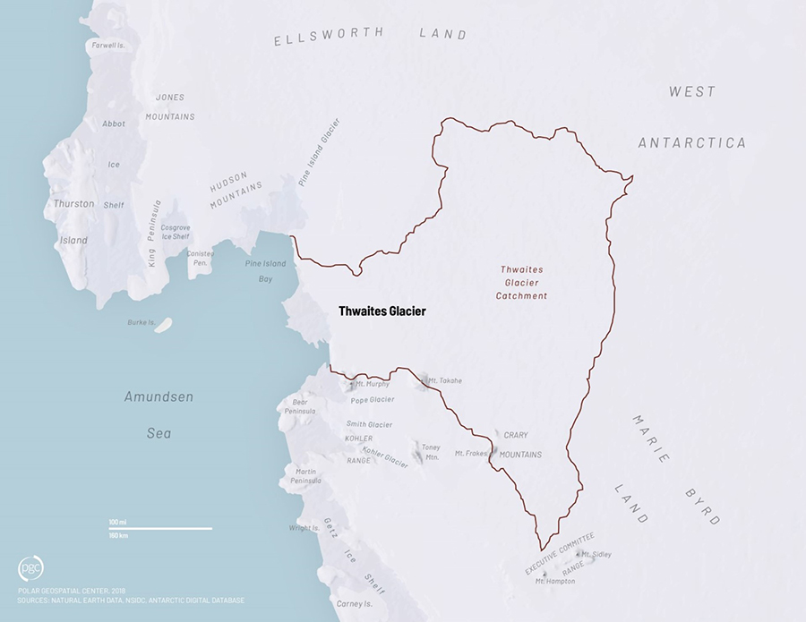
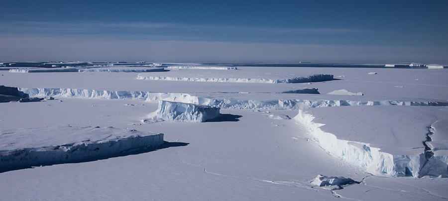
Photo Credit: The Polar Geospatial Center
The Thwaites Glacier is a vast expanse of ice in West Antarctica, covering an area about the size of Florida.
Glaciologists are tracking it with alarm, as Thwaites has lost a tremendous amount of mass over recent decades, but its remote location in West Antarctica makes getting an up-close look at it extremely difficult. Since late 2018, scientists from the United States and the United Kingdom, along with other international partners, have together launched a massive effort to travel to the region and study the glacier from the land, sea and air. They're hoping to get a more complete picture of it and put together predictions for what its future might hold. This article is the first part of a three-part series taking a deep look at the past, present and future of the Thwaites Glacier, its potential impact on the planet and the international effort to understand "The Glacier of Greatest Concern." These projects are part of the International Thwaites Glacier Collaboration (ITGC) and are supported by the National Science Foundation, which manages the U.S. Antarctic Program, and the Natural Environment Research Council, which operates the British Antarctic Survey. The combined science effort, including meetings, discussion, outreach and supporting data, is being facilitated by the ITGC Science Coordination Office. How Much How Fast?Thwaites Glacier is a mass of ice the size of Florida in West Antarctica that's melting rapidly. 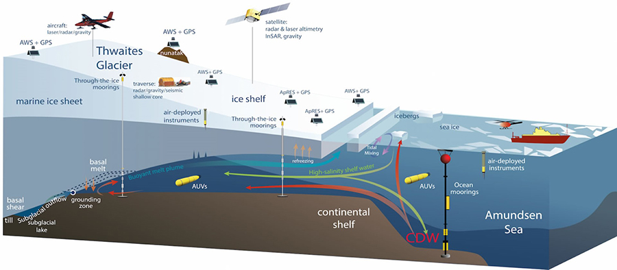
Photo Credit: The International Thwaites Glacier Collaboration
Researchers are studying the Thwaites Glacier from land, sea and air.
"The concern is that this glacier is large enough and centrally located within West Antarctica that, by itself, it represents a significant risk to increase sea level possibly before the end of this century," said Ted Scambos, a glaciologist at the University of Colorado at Boulder and U.S. lead of the ITGC science coordination office. Precise estimates vary, but worst-case estimates indicate that should the glacier completely collapse and flow into the ocean, it could raise ocean levels around the world by two feet; possibly more if it takes several adjacent glaciers along with it. Though such a complete collapse would likely take hundreds of years, a significant portion could go relatively rapidly if Thwaites melts away from the submerged rocky ridges holding it back. This sea-level change will seriously impactcoastal cities and infrastructure around the world. But because the glacier is so difficult to reach, there's a lot of uncertainty about what's happening and what's most likely to happen and when. Scientists don't have all of the data they need to pin down a better estimate of how much of the glacier is likely to collapse into the ocean or how soon. Many of West Antarctica's glaciers are showing signs of melting and thinning, but Thwaites is the one of greatest concern because of its key location in the center of West Antarctica and the vast area of upstream ice that flows into it. Satellite images show that the glacier has been picking up speed since the 1970s as it cascades into the ocean, and that this acceleration seems to have been increasing since the beginning of the new millennium. On top of that, the bedrock that Thwaites is perched upon looks precarious. The glacier is grounded on a long ridge that pins its flow, slowing its slide into the sea. However, warm seawater is melting the ice from below. Should it melt out that toehold, warm water could pour into the ice-filled canyon behind it and start a runaway collapse of the entire glacier. 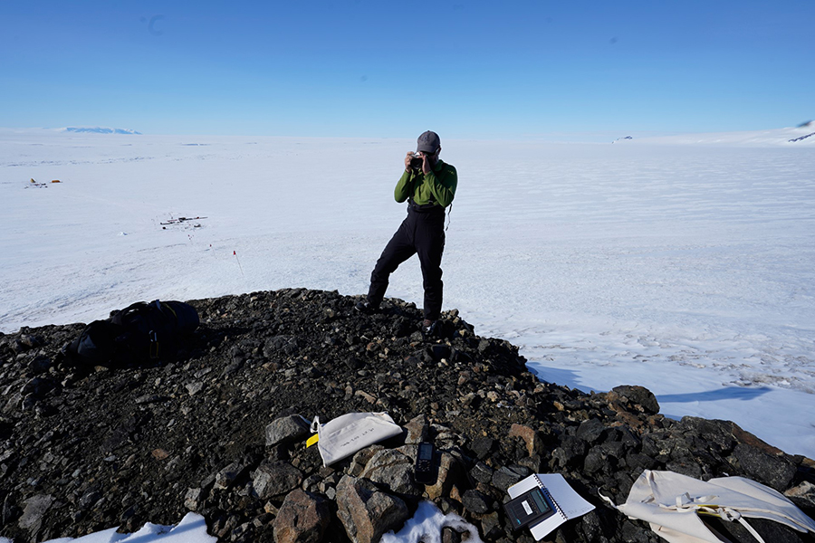
Photo Credit: Brent Goehring
Greg Balco stands atop a rocky outcrop along Mount Murphy, adjacent to Thwaites Glacier.
"That step right there makes the whole coastline around Thwaites vulnerable to melting. It's all shown signs of melting and thinning, but for Thwaites in particular, this unfortunate geographic setting means that it's the one that can really unleash the genie," Scambos said. The International Thwaites Glacier Collaboration is a joint U.S. and U.K. effort to send teams of researchers to the remote region to study all aspects of the glacier and start answering the important underlying question of "how much and how fast?" It's composed of six field projects collecting data about the glacier's past and present, and two modeling efforts to better predict its future. Altogether, more than 130 scientists from around the world are participating in the collaboration. Over the past three years, research teams have traveled to the Thwaites Glacier by land, sea and air, analyzing the ice itself, the land it's perched on and the surrounding ocean. "It's a whole set of projects… kind of under, over, around and through the Thwaites Glacier region," Scambos said. "A major and coordinated program was needed to get the most out of everybody's research." Ancient ThwaitesOne of the first steps in predicting the future of the Thwaites Glacier is to map out its past. 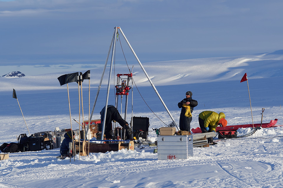
Photo Credit: Greg Balco
(Left to Right) Elliot Moravec, Grant Boeckman and Seth Campbell operate the ice drill boring through the top layers of the glacier to collect rock cores from beneath the ice.
"Understanding how Thwaites has behaved in the past is one of the ways that we might understand a little bit more about what controls it and how it will respond to changes," said Julia Wellner, a sedimentologist at the University of Houston and a principal investigator on the Thwaites Offshore Research project, known as THOR. Over the past several millennia, planet Earth has emerged out of the last major glacial period and transitioned into an "interglacial period," where global temperatures have risen and fallen by a degree or two. Exactly how glaciers in Antarctica like Thwaites expanded and contracted in conjunction with the changing temperatures is not well understood. As Earth's climate today continues to warm even more, the past could provide a preview of what's to come. Determining exactly how much the ice has changed over time requires digging up clues in rocks and sediment that survived the changing ice sheet. Two of the projects, Geological History Constraints, or GHC, and THOR, are looking for this evidence near the tops of mountains and at the bottom of the sea, respectively. "We know the ice was bigger during the last ice age and it's thinned," said Brent Goehring, a glacial geologist at Tulane University and a principal investigator on the GHC project. "Did ice reach the present elevation 5,000 years ago and then just sit there, or did it continue to thin and has it regrown in the recent past? That has important implications for what Thwaites Glacier is capable of doing in terms of if it was thinner in the relatively recent past, when was it, how much thinner was it, and what was the climate like when that happened, if it happened?" Though both projects are looking at the history of the glacier, they're approaching it from different directions. Goehring and the GHC team are the terrestrial side of things. They spent the 2019/2020 Antarctic summer season scrambling over mountain peaks sticking out of the glacier to glean insight into its thickness millennia ago. 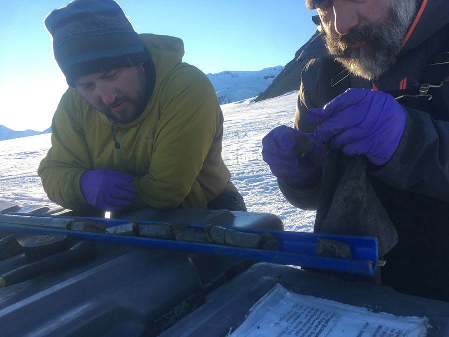
Photo Credit: Grant Boeckman
Brent Goehring (left) and Greg Balco analyze rock cores collected from the top layers of the bedrock beneath the glacier.
On the other end of the glacier, Wellner and the THOR team are looking for traces of when the ice sheet was bigger and extended farther off the continent into the nearby Amundsen Sea. Using the research vessel Nathaniel B. Palmer, she and her team are collecting samples from the seafloor and mapping it to look for clues about the glacier's history. "We study where it used to be and we use geophysics and sediment coring to study where the ice has retreated from," Wellner said. "The reason we do that is to understand how it retreated, what made it retreat in the past?" The Heights of IceIn December of 2019, Goehring and his team traveled to Mount Murphy, a volcanic peak along the edge of Thwaites. Mount Murphy is a nunatak, a mountain almost entirely enveloped by ice with only its peak sticking out. "It's really the closest bit of exposed rock to the Thwaites glacier system," Goehring said. At the same time, a UK team traveling from the British Rothera Station flew to the Hudson Mountains along another part of the glacier to scout out sites for future sampling sites. 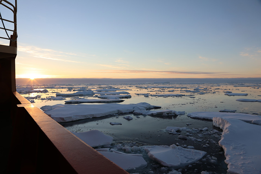
Photo Credit: Linda Welzenbach
The sun hangs low over the horizon as the research vessel Nathaniel B. Palmer approaches the Thwaites Glacier through icy waters.
The sites that the teams are sampling are close to the edge of the glacier. The ice there is relatively thin today, and if the glacier was smaller thousands of years ago, more of the mountainside would have been exposed. Goehring and his team used an ice drill to bore through the few meters of ice and collect samples of bedrock covered by the glacier for thousands of years. He and his team are using a technique called cosmogenic nuclide dating to determine how long the underlying bedrock has been buried. Exposed rock on Earth's surface is constantly bombarded by cosmic radiation, which causes small nuclear reactions inside of them. "That changes isotopes of one element into isotopes of another element," Goehring said. "We can count how many times that has happened, and that gives us a sense of when that happened and the duration of an event." Any rocks buried under a thick layer of ice are protected from this cosmic bombardment, so the creation of rare isotopes stops, and some of the existing ones break down. By measuring the amount of embedded rare isotopes, they can get an idea of how long ago the rocks were last exposed to the surface. "We have a lot of chemistry that we have to do," Goehring said. "We have to isolate specific minerals in the core. We have to then make sure the minerals themselves are clean enough and only then can we extract the nuclide that we're interested in." Because of the COVID-19 pandemic, Goehring and his team were only recently able to begin working on their collected samples. Since November, they've been isolating and prepping the minerals they need for dating. 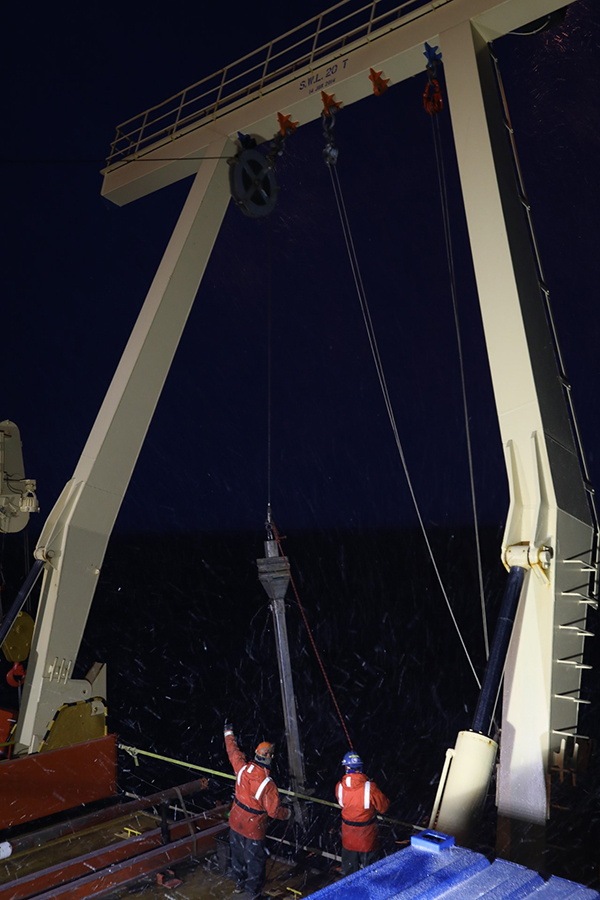
Photo Credit: Linda Welzenbach
Marine technicians prepare to lower a Kasten corer over the side of the research vessel Nathaniel B. Palmer to collect a column of sediment from the ocean floor.
Another newer technique they're also trying out is called luminescence dating. "It allows you to determine when minerals were last exposed to sunlight. So in the absence of any external stimulation, some minerals essentially develop a charge, like electrons wind up in places where they would not normally be," said Greg Balco, a geochronologist at the Berkeley Geochronology Center. "If you can determine how much of that is built up in your mineral, you can determine how long it's been since it's been reset." It's a technique that hasn't been used much in Antarctica because of how carefully the samples have to be handled. To ensure the mineral's distinctive charge is preserved, the rock cores have to be collected in pitch darkness. Any accidental flash of sunlight would affect the charge and spoil the measurement, a difficult thing to protect against in a region with 24 hours of daylight. The analysis of these samples is continuing. The GHC team's preliminary work with the luminescence dating so far seems to indicate that the blackout tents and darkroom bags they used to transport the samples worked, and they should be able to reliably date them soon. "So far the results are very preliminary, but intriguing and exciting," Goehring said. The team is planning on returning to the region in a future season to collect samples from the Hudson Mountains. Glacial DepthsJulia Wellner and the THOR team are also collecting cores from places where the ice sheet used to be, but instead of high mountain peaks, they are gathering their data from the bottom of the ocean. "The only way to study how the ice has interacted with the ocean is to do it in the ocean," Wellner said. "Our sediment cores allow us to reconstruct past ocean conditions and see if we can tie those ocean conditions to the retreat of the ice." In early 2019 and again in early 2020, Wellner and her team sailed on the research vessel Nathaniel B. Palmer to the Amundsen Sea off the coast of Thwaites Glacier. There, they hunted for clues left behind by a thick wall of ice that once existed where their boat now floated. At multiple sites off the coast, the team dropped different coring devices, heavy tubes that would plunge deep into the ocean floor to retrieve a column of sediment. These cores preserved the delicate layers of sediments that can be age-dated. 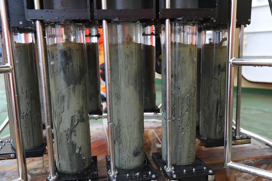
Photo Credit: Linda Welzenbach
Clear tubes full of sediment collected from the seafloor are visible after the multi-corer is deployed.
Embedded within these layers are the tiny, glass-like remains of microorganisms that populate the oceans all over the world. "Our group studies things like diatoms which are photosynthesizing algae, single cellular algae in the ocean. Different species live in different temperatures and salinities and they can be used to reconstruct past ocean conditions," Wellner said. By analyzing the kinds of diatoms they find in each layer of sediment, combined with other clues from the sediment itself, the team can tell how warm the ocean was, how salty it was and other aspects going back thousands of years. "By looking at the different characteristics of the sand and the mud and the gravel, we can tell how close the ice got to that location in the past," Wellner said. "As we go down farther and farther to the base of whatever we recover, as we're going back in time, we can see how the ice flowed, when the ice was there before." In addition, while the ship was sailing throughout the region, it at times towed a "streamer" to map the sediment layers under the surface of the ocean floor using sound. The British Antarctic Survey-owned streamer is a series of underwater microphones called hydrophones, which listen for the echoes of a sound source operating underwater from the ship. "Some of the sound, instead of bouncing off of the sea floor, some of the sound penetrates the sea floor and goes down to the next layer underneath and then it bounces back. And some sound goes even farther," Wellner said. "We end up with sound bouncing off of each layer of the subsurface coming back to the surface where the hydrophones are." Because of the pandemic, Wellner and her team have only just started analyzing their samples, but have made progress processing the mapping data. In early April, she and several other members of the THOR team were coauthors on a paper published in Science Advances outlining how more warm water than expected is melting Thwaites Glacier from below, raising concerns about an accelated ice flow into the ocean. "What we're seeing is this extraordinary variability that's really just reminding us how complicated this system is overall," Wellner said. NSF-funded research in this story: Julia Wellner, University of Houston, Award No. 1738942; Brent Goehring, Tulane University, Award No. 1738989; Ted Scambos, University of Colorado at Boulder, Award No. 1738913. |

For USAP Participants |
For The Public |
For Researchers and EducatorsContact UsU.S. National Science FoundationOffice of Polar Programs Geosciences Directorate 2415 Eisenhower Avenue, Suite W7100 Alexandria, VA 22314 Sign up for the NSF Office of Polar Programs newsletter and events. Feedback Form |